Rhynie, Barflat
Pictish Symbol Stone (Pictish)
Site Name Rhynie, Barflat
Classification Pictish Symbol Stone (Pictish)
Alternative Name(s) Rhynie No. 7
Canmore ID 17218
Site Number NJ42NE 52
NGR NJ 4976 2636
Datum OSGB36 - NGR
Permalink http://canmore.org.uk/site/17218
- Council Aberdeenshire
- Parish Rhynie
- Former Region Grampian
- Former District Gordon
- Former County Aberdeenshire
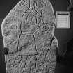
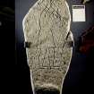
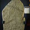
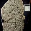
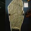
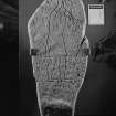
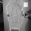
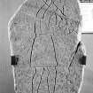
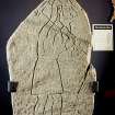
Rhynie Man. In 1978 a large slab bearing the carving of a fierce male figure, was ploughed up on the farm of Barflat,
beside the old kirkyard. It is a rare example of a small series of Pictish stones with figures and may date from the sixth or seventh century ad. Acast can be seen in the vestibule of the school; original in Woodhill House, Aberdeen.
Taken from "Aberdeenshire: Donside and Strathbogie - An Illustrated Architectural Guide", by Ian Shepherd, 2006. Published by the Rutland Press http://www.rias.org.uk
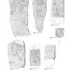
Rhynie 7, Barflat, Aberdeenshire, Pictish symbol stone
Measurements: H 1.78m, W 0.70m, D 0.39m > 0.13m
Stone type: gabbro boulder.
Place of discovery: NJ 4976 2636
Present location: Woodhill House, Aberdeen.
Evidence for discovery: found during ploughing in 1978 in a field to the south of the old kirkyard at Rhynie.
Present condition: scratched by the plough.
Description
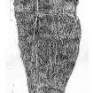
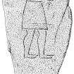
This natural boulder is incised with the ‘formidable man’ symbol, facing right and walking to the right. He wears a belted tunic and his feet appear to be shod. He grasps with both hands an axe with a very narrow shaft resting on his right shoulder. Either a headdress or long hair flows midway down his back. His head is depicted with a large ear, bushy eyebrow over a prominent oval eye, hooked nose, beard, moustache and teeth bared in a snarl.
Date: seventh century.
References: Shepherd & Shepherd 1978; Fraser 2008, no 43.7.
Desk-based information compiled by A Ritchie 2017
NJ42NE 52 4976 2636.
A slab, the main face of which has been dressed and ornamented with an incised figure 1.03m tall. Found in 1978 and now in the foyer of Woodhill House, Aberdeen, the headquarters of Grampian Regional Council.
I Shepherd 1988; RCAHMS 1994.
Reference (1978)
Found when ploughing on 10 March 1978. A roughly kite-shaped gabbro boulder, 1.78m long, 0.70m maximum width, 0.39m thick at the base and 0.13m thick at the top; incised with the figure of a Pictish man carrying an implement or weapon resembling an axe over his shoulder.
The findspot is some 40m ENE of the Craw Stane (NJ42NE 35), but the steepness of the field in this area suggests that the stone may have been plough-dragged down from an original position on the crest of the hill shoulder, near the Craw Stane. Stone is at Barflat steading (See NJ52NW 32).
I A G Shepherd and A N Shepherd 1978; 1980
Note (15 January 1997)
This Pictish stone has for some years been exhibited at Woodhill House, Aberdeen, headquarters of Aberdeenshire Council.
Information from RCAHMS (JRS), 15 January 1997.
Reference (1997)
Rhynie 8. Class I symbol stone showing an elephant, part of an ogee and a comb.
A Mack 1997.
Note (May 2017)
Discovering a Lost People
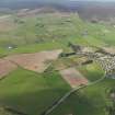
Modern day Rhynie is a rural village in central Aberdeenshire, surrounded by open countryside. It is a picturesque location, and deceptively modest, for archaeological evidence attests to many centuries of high status settlement in the area. Even the name Rhynie itself is regal, deriving from 'Rig' meaning King. Many Pictish stones have been found here, including the famous 'Rhynie Man', a 6ft high figure carrying an axe, found in a field in 1978.
So who were the Picts, and what were they doing at Rhynie? These are the very questions which are currently being investigated by The University of Aberdeen's Northern Picts project. The project aims to find the Picts in the landscape of Northern Scotland, and has had many notable successes in recent years. The Rhynie Environs Archaeology Project (REAP) is a key case study within the Northern Picts project. It is a collaborative endeavor between the Universities of Aberdeen, Chester and Glasgow and the local community artist collective Rhynie Woman.
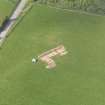
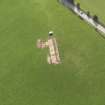
Excavations in 2011 and 2012 revealed a series of fortified enclosures near to the the Craw Stane, a Class I Pictish symbol stone which still stands today. This is located at Barflat, northwest of the present day village and very close to where Rhynie Man was found in the 1970s. Early indications were that this was an important settlement. Further work revealed a series of concentric enclosures centred on a ring ditch and other possible timber structures, and in association with the Class I symbol stone. An interpretative reconstruction of the site has recently been completed and it is available to view online. You can access it by clicking on the link below.
Settlement evidence for this period is very rare, and the evidence for Pictish buildings which has been found at Rhynie is extremely important. Equally significant is the evidence for large-scale high status metalworking at the site, and a range of Continental imports which have been found here, indicating without doubt that Rhynie was an important power centre dating from the 4th to the 6th centuries AD. A contemporary cemetery has been found closer to the village.
Contextualising Rhynie / Moulds and Metal
The Rhynie Environs Archaeology Project is investigating the interaction between the high status site here and the wider landscape. The complex at Barflat is close to two small fortified sites at Cairnmore and Wheedlemont, and the great hillfort at Tap O'Noth [see previous Archaeology InSites feature under Age of Iron]. A 5th/6th century phase has been identified at Cairnmore and it is very likely that both Wheedlemont and Tap were in use at this time, but connections between these sites and Rhynie are still to be established. Understanding the links between these sites, and indeed if they are there at all, is key to understanding the development and control of the landscape of the Strathbogie area.
Rhynie has yielded a rich assemblage of high status material. One of the most iconic finds from the site is the axe shaped pin which was found in 2012. This pin, with its serpent design, resembles the axe which is carried by Rhynie Man, now in the reception area of Woodhill House, the headquarters of Aberdeenshire Council. The 2016 excavations revealed the best evidence yet for high status metalworking at Rhynie. Over 50 sherds of crucibles were found at the site, and clay moulds were uncovered in greater numbers than at any other known Pictish site. These moulds produced a range of different pins and brooches. There was even evidence for enameling. The finds from the 2016 season are currently undergoing conservation work, and although less visually striking than the finished products, they have the potential to tell us far more.
Dr Kirsty Owen - Archaeology and World Heritage Team


