
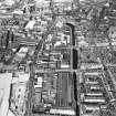
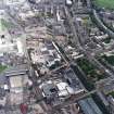
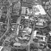
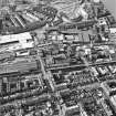
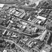
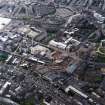
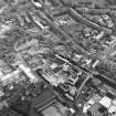
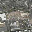
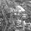
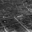
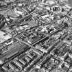
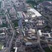
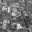
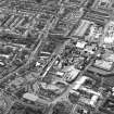
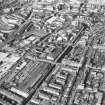
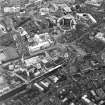
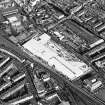
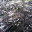
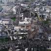
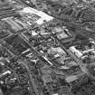
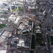
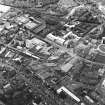
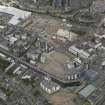
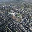
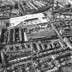
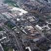
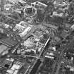
Edinburgh, Fountainbridge, Dundee Street, Fountain Brewery


Brewery (19th Century)
Site Name Edinburgh, Fountainbridge, Dundee Street, Fountain Brewery
Classification Brewery (19th Century)
Alternative Name(s) South Site; Scottish Courage Brewing Ltd; Scottish And Newcastle Beer Production Ltd; William Mcewan And Co Ltd
Canmore ID 171912
Site Number NT27SW 3127
NGR NT 24334 72721
Datum OSGB36 - NGR
Permalink http://canmore.org.uk/site/171912


- Council Edinburgh, City Of
- Parish Edinburgh (Edinburgh, City Of)
- Former Region Lothian
- Former District City Of Edinburgh
- Former County Midlothian
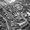
NT27SW 3127.00 24340 72715
NT27SW 3127.01 24412 72802 Boiler House
NT27SW 3127.02 24449 72750 Malt Mill and Brewhouse
NT27SW 3127.03 24372 72740 Chiller
NT27SW 3127.04 24361 72682 Fermenting Vessels Block
NT27SW 3127.05 24288 72740 M.V. Block
NT27SW 3127.06 24192 72585 High Speed Can Line
NT27SW 3127.07 24253 72700 Offices and Stores
NT27SW 3127.08 24536 72781 Canteen and Tartan Club
NT27SW 3127.09 24387 72746 Office Block and Gate House
See also
NT27SW 236.00 NT 24203 72819, Fountain Brewery (North Site).
NT27SW 2848 NT 24343 72783, North British Rubber Company (Fountain Brewery Offices)
This brewery was demolished by Scottish Courage in c. 2005.
Information from RCAHMS (MKO), 2005.
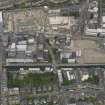
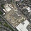
Archaeological Evaluation (14 September 2015 - 18 September 2015)
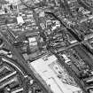
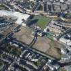
AOC Archaeology Group was commissioned by the EDI Group Ltd to undertake an archaeological evaluation prior to the construction of new housing at a site in Fountainbridge, as part of a planning condition. The development area consisted of two large areas between Viewforth and Fountainbridge, separated by Gilmore Park. Prior to this development, the site had been occupied by the Fountainbridge Brewery, built in the 1970s, which was built on the site of the former Castle Mill Works. Originally, a 10% sample of the 3.2 ha development area was required. However, due to the large presence of live services, some areas inaccessible due to their use as community plots, and the depth of made ground encountered during the evaluation, 695m² was finally evaluated, equating to nearly 2.5% of the development area. In all trenches there was a significant amount of made ground ranging from 1.45m – 3m in depth. Therefore, it is unlikely that much of the original footings or features associated with the 19th century industrial works have survived, these being demolished and also as a levelling course for the new Fountainbridge Brewery. The only possible 19th century feature identified was a brick culvert (Trench 3) to the south-west of the development plot in the area of the former Castle Mills.
Information from Diana Sproat (AOC Archaeology Group) 25 September 2015.OASIS ID: aocarcha1-224583

