
Pricing Change
New pricing for orders of material from this site will come into place shortly. Charges for supply of digital images, digitisation on demand, prints and licensing will be altered.
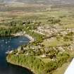
Mull, Tobermory Harbour, New Pier


Pier (Period Unassigned)
Site Name Mull, Tobermory Harbour, New Pier
Classification Pier (Period Unassigned)
Alternative Name(s) Tobermory Bay; Mishnish Pier; Steamer Pier; Sound Of Mull
Canmore ID 171607
Site Number NM55NW 19.02
NGR NM 5079 5529
Datum OSGB36 - NGR
Permalink http://canmore.org.uk/site/171607


- Council Argyll And Bute
- Parish Kilninian And Kilmore
- Former Region Strathclyde
- Former District Argyll And Bute
- Former County Argyll

