Pricing Change
New pricing for orders of material from this site will come into place shortly. Charges for supply of digital images, digitisation on demand, prints and licensing will be altered.
Kildrummy, St Bride's Chapel And Well
Burial Ground (Medieval), Chapel (6th Century) (581), Church (14th Century), Holy Well (Medieval)
Site Name Kildrummy, St Bride's Chapel And Well
Classification Burial Ground (Medieval), Chapel (6th Century) (581), Church (14th Century), Holy Well (Medieval)
Alternative Name(s) Kildrummy Old Kirk; Kildrummy, Old Parish Church; Kildrummy Kirk; Kildrummy Church
Canmore ID 17101
Site Number NJ41NE 3
NGR NJ 47245 17556
NGR Description NJ 47245 17556 and NJ 47196 17480
Datum OSGB36 - NGR
Permalink http://canmore.org.uk/site/17101
- Council Aberdeenshire
- Parish Kildrummy
- Former Region Grampian
- Former District Gordon
- Former County Aberdeenshire
There is some debate whether the calm green mound on which the old kirk of Kildrummy sits is a Norman motte or castle mound, the precursor of Kildrummy Castle. Its elevated site at the end of a ridge is a natural feature and the mounding is not inconsistent with the development of an ancient graveyard. Dedicated to St Bride and once called the 'chapel of the lochs' from the encircling marsh, the upstanding walls are mostly those of relatively recent burial enclosures, making the plan of the old kirk difficult to discern.
However, there is a wealth of tombstones from the 16th century onwards, including some fine armorial stones. Original archway survives as a tomb recess behind wooden doors; excellent stone with three praying figures in half relief.
Taken from "Aberdeenshire: Donside and Strathbogie - An Illustrated Architectural Guide", by Ian Shepherd, 2006. Published by the Rutland Press http://www.rias.org.uk
NJ41NE 3 47245 17556 and 47196 17480
(NJ 4724 1754) St Bride's Chapel (NR) (Remains of)
(NJ 4718 1747) St Bride's Well (NR) (Site of)
OS 6" map, Aberdeenshire, 2nd ed., (1902)
For motte tentatively identified within the churchyard, see NJ41NE 38.
For present parish church (NJ 4722 1758), see NJ41NE 39.
The ruins of the parish church of Kildrummy, 75ft by 24ft, and c.10ft high, erected in 1385, (A Laing 1828) and dedicated to St. Bride, occupy the top of a glacial mound. The south porch forms the Elphinston aisle which dates from 1605. Beside the church was St. Bride's Well.
A Laing 1828; W D Simpson 1943; H Scott (Fasti Eccles Scot) 1943.
All that remains of St. Bride's Chapel is the N wall, 16.5m long, 3.0m high and 0.8m thick, containing a Medieval grave recess, and later graveslabs built into the face, Otherwise the wall is featureless, all window apertures being blocked, and a modern coping being provided. According to the plaque in the present church written by the late minister, a chapel dedicated to St. Bennet was first established in Kildrummy in 581 AD by King Brude. Probably this stood where St. Bride's Chapel stands, as the situation is prominent, and because of the similarity between the names Brude and Bride. The present ruins, it is believed, date from 1335 AD or earlier. The Elphinston Aisle (the south porch described above) was built in 1605, and still remains entire. The majority of the chapel was removed in 1805 to build the present church, which is still in used as is the graveyard. There is no trace of St. Bride's Well.
Revised at 1/2500.
Visited by OS (N K B) 20 September 1968.
The font from the old kirk is held in the present church (NJ41NE 39).
I A G Shepherd 1986.
Approximately circular enclosure; motte crowned by remains of old church. Tombstones from 16th century onwards.
[Air and ground photographic imagery listed].
NMRS, MS/712/36.
Field Visit (19 November 1996)
In 1362 Kildrummy was granted as a common church to the dean and chapter of the cathedral of Aberdeen by Thomas, earl of Mar (Cowan 1967, 100). What remains of the former parish church stand on a steep-sided knoll on the crest of a ridge flanked by low-lying boggy ground. It served the parish until its partial demolition in 1805 (when the present building was erected at the foot of the knoll) and it is now reduced to a stretch of its N and E walls. These have been consolidated, probably in the nineteenth century, and a course of coping stones added. The N wall, presently 16.95m long from ENE to WSW, evidently continued beyond its present WSW end, as footings are visible continuing underneath the adjacent burial-enclosure. The E gable, which has been reduced to a uniform height with the N wall, survives for a length of 4.1m.
A number of features survive. In the outer face of the N wall a small blocked window with chamfered opening is visible. Internally this survives as a recess in the wall. The W side retains its splay, but the E side has been replaced, probably in the nineteenth or early twentieth century. The lintel is likewise a later repair. Just below the internal sill of the window is a rectangular socket of unknown purpose. To the E of the window a shallow recess on the inner face of the wall probably indicates the former position of a mural plaque.
Towards the ENE end of the N wall is its main feature. This is a pointed arched tomb recess, enriched with a moulded opening. On the E side of this is a decorated finial, possibly the remains of a pilastered frame. The tomb is afforded some protection by a now decrepit timber and asbestos shelter. The original effigy or other monument for which the recess was intended is lost, and it now houses two monuments brought from elsewhere in the church or burial ground.
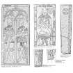
The principal of these is a large, late medieval graveslab. As the slab is too long to fit into the recess, it has been slightly truncated, and the lower jamb stones of the recess have been removed. The slab bears on its upper face the effigies, in low relief, of (dexter) a knight, and (sinister) his lady, their heads resting upon rectangular, tasseled, cushions. The knight is clad in plate armour, his head encased by a large, visorless, plumed bascinet. His shoulders and neck are covered by a mail coif, although there is a possibility plate armour is intended. His body, arms and legs are all clad in plate. His hips are enclosed in a skirt of horizontal plates, or tasses. On his right side, slung from his waist, he wears a dagger with round pommel. The lady wears a long, close-fitting gown with plaited skirt, and a full coif. The hands of both figures are raised in prayer.
Along the exposed edge of the slab runs an inscription in Gothic lettering, cut in low relief: ‘hic iacet alxdar de forbes quondam dns de burchis et Mariota….’ (here lies Alexander de Forbes, late lord of Brux and Mariota …..). The remainder of the inscription has been lost with the truncation of the slab. Whyte (1936, 165) supplies the continuation as: sporsa eius 155- (his wife 155-), but it is not apparent from where this derives. Simpson (1949, 47-8; see also 1943, 144) discusses the problems encountered in dating this slab, and suggests that it is a fifteenth century slab reused in the sixteenth century. However, bearing in mind the conservatively styled effigies encountered elsewhere in the north-east, it is probable that the slab, both effigy and inscription, are of sixteenth century date. The second monument in the recess is a well-preserved eighteenth century graveslab. The remains of the E gable are featureless and it has clearly been partially reconstructed.
To the S of the remains of the wall stands the Elphinstone Aisle, an early sixteenth century burial aisle measuring 5.75m from N to S by 5.2m. It is of rubble and mortar construction, with steeply pitched crow-stepped gables and a slated roof. The SW and SE skewputts bear, respectively, the initials IL and IL LE. Entry to the aisle is currently by a door in the S gable, the lintel of which bears a weathered inscription. This is again supplied by Wright as ‘Yis yle vas built be A. E. in 1605 yeiris. Lord bliss us.’ (1936, 166). The interior of the aisle is illuminated by a glazed light over the doorway. Above this a plaque records the restoration of the aisle in 1868. The W wall preserves a blocked doorway with chamfered jambs. Although the lintel bears a similar chamfered, it is evidently in reuse, as it is intended for a narrower opening. Built into the doorway is an eighteenth century graveslab bearing the winged soul or angel, and symbols of mortality. Although now a free-standing building, the Elphinstone aisle formerly abutted the S side of the church. A single tusker stone still protrudes from the W wall, immediately N of the blocked doorway. A length of footings running E and W in line with this emerges from beneath a recumbent slab set against the aisle’s W wall.
Visited by RCAHMS (IF, AW) 19 November 1996.
Publication Account (1996)
This unusu al, rectangular, bow-fronted church with central bellcote replaced, in 1805, the pre-Reformation church whose remains still stand on the green kirkyard mound behind. Within all is light and airy, the pulpit being placed between two large windows on the east, with a horseshoeshaped gallery of light wood opposite. The font from the old kirk is here.
There is some doubt whether the grassy mound on which th e old kirk of St Bride's sits was a motte, the precursor of the castle at Kildrummy (no. 30). An arched Gothic recess on the north wall, possibly an Easter sepulchre, contains a fine relief effigy slab to the fourth laird of Brux, c 1400, which was reused in the 16th century.
Information from ‘Exploring Scotland’s Heritage: Aberdeen and North-East Scotland’, (1996).
Measured Survey (27 April 2000)
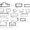
RCAHMS measured survey including 1:250 site plan and 1:20 plan and elevation of burial recess. An plan of the church only was prepared in graphic vector software and published at the reduced scale of 1:500 (RCAHMS 2007, fig. 8.32).
Measured Survey (4 July 2001)
RCAHMS measured survey of relief-carved medieval grave-slab at 1:10. Redrawn in ink at 1:5.


