
Salt Knowe


Cairn (Period Unassigned)
Site Name Salt Knowe
Classification Cairn (Period Unassigned)
Alternative Name(s) Ness Of Brodgar
Canmore ID 1701
Site Number HY21SE 14
NGR HY 2927 1328
Datum OSGB36 - NGR
Permalink http://canmore.org.uk/site/1701


- Council Orkney Islands
- Parish Stenness
- Former Region Orkney Islands Area
- Former District Orkney
- Former County Orkney
HY21SE 14 2927 1328.
(HY 2927 1328) Salt Knowe (NR)
OS 6" map, Orkney, 2nd ed., (1903).
This mound was described in 1848 (F W L Thomas 1852) as a large conoid tumulus 20 ft high and 59 ft in diameter, and as possibly the mound in which Wallace said that nine silver penannular fibulae (ring-money: Grieg) were found.
S Grieg 1940; RCAHMS 1946.
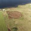
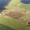
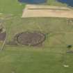
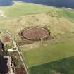
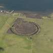
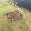
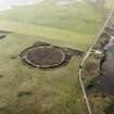
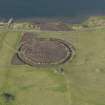
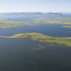
'Salt Knowe' (locally-accepted name) is a mound measuring 40.0m. NW to SE by 33.0m. transversely and 5.8m. high. It is grass-covered, with many rabbit-scrapes, but with a large stony content. On the south edge of its flat top there is a cist-like structure, oriented east and west, 2.6m. long, 1.0m. wide and possibly 1.0m. deep, with the west end missing and a dividing slab 2.0m. from the east end. The interior is filled with debris.
No further information was obtained.
Resurveyed at 1/2500.
Visited by OS (RB) 24 April 1966.
The 'John O'Groat Journal' in 1854 gives a brief description of this site.
M Howe 2006
Field Visit (24 April 1966)
'Salt Knowe' (locally-accepted name) is a mound measuring 40.0m. NW to SE by 33.0m. transversely and 5.8m. high. It is grass-covered, with many rabbit-scrapes, but with a large stony content. On the south edge of its flat top there is a cist-like structure, oriented east and west, 2.6m. long, 1.0m. wide and possibly 1.0m. deep, with the west end missing and a dividing slab 2.0m. from the east end. The interior is filled with debris.
No further information was obtained.
Resurveyed at 1/2500.
Visited by OS (RB)
Field Visit (1 May 1994)
It is not certain to what extent this mound has been damaged through excavation. The cist that is now visible on the slope from the top to the SE is large, appears to have its top intact and through a gap can be seen to be filled with sand. It is possible that this is not the same cist that the OS notes on the S side which is said to have its W side missing.
The mound is large, measuring 37.3m by 33.5m and is 5.15m in height. It is very prominent due to its large size, especially to the NW and SE.
Information from the Orkney Barrows Project (JD), 1994

