
Pricing Change
New pricing for orders of material from this site will come into place shortly. Charges for supply of digital images, digitisation on demand, prints and licensing will be altered.
Roman Camp Gate


Roundhouse(S) (Prehistoric)
Site Name Roman Camp Gate
Classification Roundhouse(S) (Prehistoric)
Alternative Name(s) Den Farm; Romancamp Gate
Canmore ID 16934
Site Number NJ36SE 15
NGR NJ 3568 6172
NGR Description NJ 3568 6172, NJ 3568 6169 and NJ 3576 6167
Datum OSGB36 - NGR
Permalink http://canmore.org.uk/site/16934


- Council Moray
- Parish Bellie
- Former Region Grampian
- Former District Moray
- Former County Morayshire
NJ36SE 15 357 617.
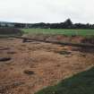
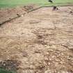
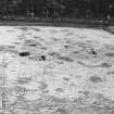
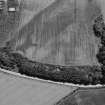
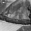
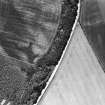
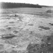
(Location cited as NJ 3568 6172). Roman Camp Gate. This 'native settlement' is situated on level ground near the top edge of an escarpment at an altitude of about 23m OD. It comprises at least five timber roundhouses; a large N-facing house occupies the same site as one of the four smaller E-facing houses. Pairs of large postholes mark the entrances to a palisaded enclosure around each house.
[Air photographic imagery listed and report on 1980 excavations appended].
NMRS, MS/712/36.
Excavation was undertaken to test hypotheses relating to the date and function of cropmark pit circles and to what extent could these different functions be detected in morphological differences visible on aerial photographs.
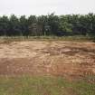
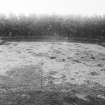
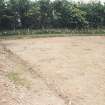
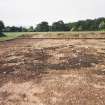
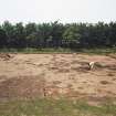
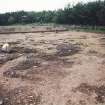
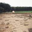
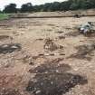
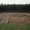
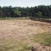
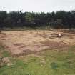
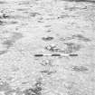
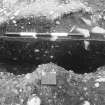
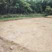
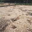
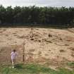
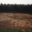
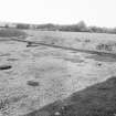
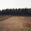
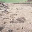
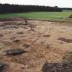
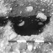
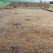
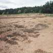
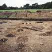
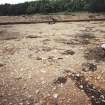
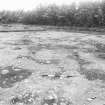
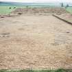
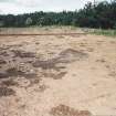
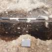
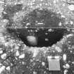
RCAHMS aerial photographs, dating from 1977, revealed traces of three pit circles in a field on Den Farm, in which a cist had been found in 1868 (NJ36SE 4). One circle was significantly larger than the others, with a scatter of other large pits around and within it. It was chosen for excavation. An area measuring a maximum of 25m by 23m stripped. Over 300 separate features (mainly postholes) were noted and planned. A sample of about 33 features was half sectioned to determine the nature of types of features and to establish important relationships between feature groups.
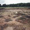
Cleaning and planning revealed a number of groupings of features:
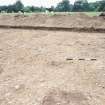
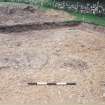
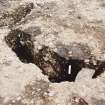
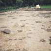
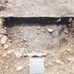
1. Post circle A - a ring probably of 14 large postholes measuring 8.5m in diameter, with posts about 1.8m apart.
2. Post circle B - a ring probably of 14 large postholes, 8.5m in diameter, with posts about 1.65m apart. Elements of this ring had been burnt in situ.
3. Post circle C - a ring of 16 large postholes, 11.5m in diameter, with posts about 2.25m to 2.5m apart.
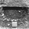
Excavation showed that the pits of post circle A had been cut by those of post circle B, which in turn had been cut by those of post circle C. 4. Post circle D - an arc of a possible fourth ring of posts; 6 postholes of this possible group were visible at the N edge of the site. The ring would have been about 9m in diameter.
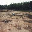
5. An arc of 11 small postholes, possibly part of a ring of very different character from A-D.
6. The possible fences - a prominent feature of the site was a distinct line of posts running from the SW baulk for 3m terminating at a post. The fence resumed on the other side of a possible gate 11m across. Another possible fence was visible as a continuous narrow strip running across rings A, B and C.
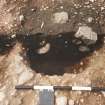
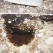
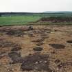
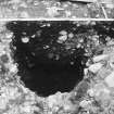
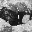
7. Two ill-defined hollows. One emerged from the NW. The fill of the other obscured postholes of rings A, B and C. It contained an area of paving, perhaps a survival in the slight hollow of more extensive paving. The hollow had a distinct resemblance of excavated ring ditch houses.
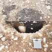
The only finds recovered were flint tools and flakes, fragments of burnt bone, two whetstones, a fragment of a rubbing stone, and tiny pieces of glassy slag.
Sponsor: Historic Scotland. (For plan: see fig 10k).
GJ Barclay and M Tolan 1990.
The excavation was undertaken to test hypotheses relating to the interpretation of cropmark pit circles: were they Neolithic or Bronze Age ceremonial or funerary structures, or were they Iron Age houses and to what extent could the two classifications be differentiated on aerial photographs? The excavation revealed the remains of four circles (between 8.5m and 11.5m in diameter) of large postholes, fence lines (one with a gate), and many other pits and post-holes. Radiocarbon dates place the post circle late in the first millenium BC uncal. The pit circles may be interpreted as the main structural elements of four substancial round houses, two of which burned down. Flint tools of the Mesolithic period were recovered.
G J Barclay 1993
Aerial Photographic Transcription (21 February 1990)
An aerial transcription was produced from oblique aerial photographs. Information from Historic Environment Scotland (BM) 31 March 2017.
Excavation (1990)
Excavation was undertaken to test hypotheses relating to the date and function of cropmark pit circles and to what extent could these different functions be detected in morphological differences visible on aerial photographs.
RCAHMS aerial photographs, dating from 1977, revealed traces of three pit circles in a field on Den Farm, in which a cist had been found in 1868 (NJ36SE 4). One circle was significantly larger than the others, with a scatter of other large pits around and within it. It was chosen for excavation. An area measuring a maximum of 25m by 23m stripped. Over 300 separate features (mainly postholes) were noted and planned. A sample of about 33 features was half sectioned to determine the nature of types of features and to establish important relationships between feature groups.
Cleaning and planning revealed a number of groupings of features:
1. Post circle A - a ring probably of 14 large postholes measuring 8.5m in diameter, with posts about 1.8m apart.
2. Post circle B - a ring probably of 14 large postholes, 8.5m in diameter, with posts about 1.65m apart. Elements of this ring had been burnt in situ.
3. Post circle C - a ring of 16 large postholes, 11.5m in diameter, with posts about 2.25m to 2.5m apart.
Excavation showed that the pits of post circle A had been cut by those of post circle B, which in turn had been cut by those of post circle C. 4. Post circle D - an arc of a possible fourth ring of posts; 6 postholes of this possible group were visible at the N edge of the site. The ring would have been about 9m in diameter.
5. An arc of 11 small postholes, possibly part of a ring of very different character from A-D.
6. The possible fences - a prominent feature of the site was a distinct line of posts running from the SW baulk for 3m terminating at a post. The fence resumed on the other side of a possible gate 11m across. Another possible fence was visible as a continuous narrow strip running across rings A, B and C.
7. Two ill-defined hollows. One emerged from the NW. The fill of the other obscured postholes of rings A, B and C. It contained an area of paving, perhaps a survival in the slight hollow of more extensive paving. The hollow had a distinct resemblance of excavated ring ditch houses.
The only finds recovered were flint tools and flakes, fragments of burnt bone, two whetstones, a fragment of a rubbing stone, and tiny pieces of glassy slag.
Sponsor: Historic Scotland. (For plan: see fig 10k).
GJ Barclay and M Tolan 1990.
Aerial Photographic Interpretation (10 April 2014)
Excavation has demonstrated that the circles of pits represent the post rings of later prehistoric round houses. As such, the pit circle classification has been removed.
Information from RCAHMS (KMM) 10 April 2014

