
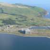
Nigg Ferry, Submarine Mining Station


Submarine Mining Station (20th Century)
Site Name Nigg Ferry, Submarine Mining Station
Classification Submarine Mining Station (20th Century)
Alternative Name(s) Cromarty Defences; Nigg Pier; Cromarty Firth; Firth Of Cromarty
Canmore ID 169300
Site Number NH76NE 291
NGR NH 79639 68894
NGR Description Centred NH 79639 68894
Datum OSGB36 - NGR
Permalink http://canmore.org.uk/site/169300


- Council Highland
- Parish Nigg (Ross And Cromarty)
- Former Region Highland
- Former District Ross And Cromarty
- Former County Ross And Cromarty
NH76NE 291 centred 79639 68894
See also NH76NE 45.00 and NH76NE 292.
The former Submarine Mining Depot at Nigg is situated immediately N of the pier (NH76NE 45.00). Consisting of a large corrugated iron shed with camouflage paint still visible and, to the rear, a concrete magazine with lightning conductors still in situ. Railway lines are still extant in the concrete leading down to the pier.
J Guy 2000; NMRS MS 810/10, Vol.2, 113, Vol.3, 43
The former World War II Submarine Mining Depot stands about 185m N of the pier at Nigg Ferry (NH76NE 45.00).
The site retains two main structures, the corrugated iron and brick shed and a large shuttered concrete magazine.
The saw tooth roofed shed which retains camouflage painting measures about 57m by 25m overall excluding the later asbestos extension and lean-to on the E side. The roof is in five segments with N lights. The building is mainly in corrugated iron, but the lower walls are of brick. There is a small contemporary extension at the NW corner. The windows and doors would appear to have concrete llintels and sills.
Internally the shed has been subdivided into small numbered cubicles abutted against the E and W walls, which were inserted to accommodate the later Nigg Welding School. The cubicles are all numbered, but a previous numbering system was noted on the original walls, all numbered in a 'Z' series, these may be original.
The main entrance at the S end is a sliding door with railed guides which intersect the narrow gauge tramway, the tracks of which are still visible in the concrete floor of the shed. The tramway has a crossover within the shed and there is evidence to the immediate S that this system extended down to the pier.
Externally on the W wall are demarked car parking spaces which retain painted names, these are most probably from the Welding School period.
The additional later extension and lean-to on the E side are constructed in asbestos sheeting and corrugated asbestos roofing. A water tower survives on the E side supported by girders.
72m to the N is a large shuttered concrete and brick magazine.
The outer shuttered concrete bomb proof walls measures about 19m by 16m, whilst the inner 'bunker' measures about 15m by 11m and standing about c.10m high. The main entrance is on the S wall via an iron or steel green painted sliding door with smaller personnel entrances in both the N and S walls. The roof is of reinforced concrete.
Internally a three-quarter height floor supported by concrete brackets has been removed and there are few other features surviving within. The floor appears to have been raised slightly to a level above ground level.
All other surrounding buildings, huts and sheds have been demolished.
Visited by RCAHMS (DE, AL), 9 February 2010.
Field Visit (29 May 2019)
Although the buildings have now been demolished, the security fence and its gates still survive. This fence was briefly evaluated in order to compare it with the Second World War fence surrounding Site No.1 at the North Sutor (NH86NW 9.51). While it is very similar, the end-posts of the bays differ in rising above the palisade before bending outwards to carry three strands of barbed wire.
Visited by HES (ATW, AKK), 29 May 2019

