
Pricing Change
New pricing for orders of material from this site will come into place shortly. Charges for supply of digital images, digitisation on demand, prints and licensing will be altered.
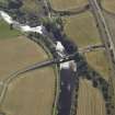
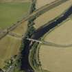
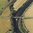
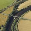
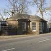
Marykirk Bridge, Tollhouse


Toll House (Post Medieval)
Site Name Marykirk Bridge, Tollhouse
Classification Toll House (Post Medieval)
Alternative Name(s) Marykirk, North Water Bridge; River North Esk
Canmore ID 168454
Site Number NO66SE 45
NGR NO 68549 64977
Datum OSGB36 - NGR
Permalink http://canmore.org.uk/site/168454


- Council Angus
- Parish Logie Pert
- Former Region Tayside
- Former District Angus
- Former County Angus
NO66SE 45 68549 64977
Toll House [NAT]
OS 1:10,000 map, 1977.
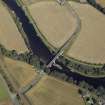
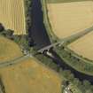
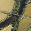
For adjacent Marykirk Bridge, see NO66SE 21.
The tollhouse, also built by Robert Stevenson in 1814, is a single-storey ashlar structure, with three semicircular bays. It has recently been extended.
J R Hume 1977.
This bridge is situated on the N side of the A937 public road, at the SW end of Marykirk Bridge (NO66SE 21) and on the SW bank of the River North Esk.
Information from RCAHMS (RJCM), 26 September 2000.
Photographic Survey (3 March 2011)
Photographed by RCAHMS for the Listed Buildings Area Survey.

