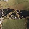
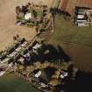
Accessibility

Font Size

100% 150% 200%

Background Colour

Default Contrast
Close Reset

Kirkstyle

Farmstead (Period Unassigned)

Site Name Kirkstyle

Classification Farmstead (Period Unassigned)

Canmore ID 167236

Site Number NJ52SE 107

NGR NJ 5975 2461

Datum OSGB36 - NGR

Permalink http://canmore.org.uk/site/167236

Ordnance Survey licence number AC0000807262. All rights reserved.
Canmore Disclaimer. © Bluesky International Limited 2025. Public Sector Viewing Terms

Toggle Aerial | View on large map

Digital Images

Oblique aerial view of Leslie Parish Church centred on the church and burial ground with manse, farmstead and road bridge adjacent, taken from the W.
Oblique aerial view of Leslie Parish Church centred on the church and burial ground with manse, farmstead and road bridge adjacent, taken from the W.Oblique aerial view of Leslie Castle centred on the castle with church, burial ground, road bridge, manse, farmstead and farmhouse adjecent, taken from the SW.

Administrative Areas

  • Council Aberdeenshire
  • Parish Leslie (Gordon)
  • Former Region Grampian
  • Former District Gordon
  • Former County Aberdeenshire

References

MyCanmore Image Contributions


Contribute an Image

MyCanmore Text Contributions