|
Photographs and Off-line Digital Images |
D 36354 CN |
RCAHMS Aerial Photography |
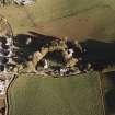
Oblique aerial view of Leslie Castle centred on the castle with church, burial ground, road bridge, manse, farmstead and farmhouse adjecent, taken from the SW. |
26/10/1998 |
Item Level |
|
|
Photographs and Off-line Digital Images |
D 36353 CN |
RCAHMS Aerial Photography |
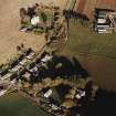
Oblique aerial view of Leslie Parish Church centred on the church and burial ground with manse, farmstead and road bridge adjacent, taken from the W. |
26/10/1998 |
Item Level |
|
|
Photographs and Off-line Digital Images |
E 33914 CN |
Survey of Private Collections |
Photographic copy of a plan the lands of the Mill and Glebe of Leslie, from a book of plans of the estate of Leith Hall belonging to General Alex Hay of Rannas, surveyed by George Brown, 1797. |
1797 |
Item Level |
|
|
Photographs and Off-line Digital Images |
E 33913 |
Survey of Private Collections |
Photographic copy of a plan of the lands of Mill and Glebe of Leslie, from a book of plans of the estate of Leith Hall belonging to General Alex Hay of Rannas, surveyed by George Brown, 1797. |
1797 |
Item Level |
|
|
Photographs and Off-line Digital Images |
E 33917 |
Survey of Private Collections |
Photographic copy of a plan the lands of Chapeltown, from a book of plans of the estate of Leith Hall belonging to General Alex Hay of Rannas, surveyed by George Brown, 1797. |
1797 |
Item Level |
|
|
Photographs and Off-line Digital Images |
E 33918 CN |
Survey of Private Collections |
Photographic copy of a plan the lands of Chapeltown, from a book of plans of the estate of Leith Hall belonging to General Alex Hay of Rannas, surveyed by George Brown, 1797. |
1797 |
Item Level |
|
|
Photographs and Off-line Digital Images |
SC 1377931 |
Survey of Private Collections |
Photographic copy of a plan the lands of Chapeltown, from a book of plans of the estate of Leith Hall belonging to General Alex Hay of Rannas, surveyed by George Brown, 1797. |
1797 |
Item Level |
|
 |
On-line Digital Images |
SC 1674232 |
RCAHMS Aerial Photography |
Oblique aerial view of Leslie Parish Church centred on the church and burial ground with manse, farmstead and road bridge adjacent, taken from the W. |
26/10/1998 |
Item Level |
|
 |
On-line Digital Images |
SC 1674233 |
RCAHMS Aerial Photography |
Oblique aerial view of Leslie Castle centred on the castle with church, burial ground, road bridge, manse, farmstead and farmhouse adjecent, taken from the SW. |
26/10/1998 |
Item Level |
|


