
Paddockhaugh


Field System (Period Unassigned), Settlement (Period Unassigned)
Site Name Paddockhaugh
Classification Field System (Period Unassigned), Settlement (Period Unassigned)
Alternative Name(s) Birnie Kirk; River Lossie
Canmore ID 16419
Site Number NJ25NW 17
NGR NJ 207 586
Datum OSGB36 - NGR
Permalink http://canmore.org.uk/site/16419


- Council Moray
- Parish Birnie
- Former Region Grampian
- Former District Moray
- Former County Morayshire
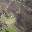
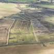
NJ25NW 17 207 586.
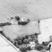
Trapezoidal settlement with field system.
G D B Jones and I Keillar 1984.
(Location cited as NJ 207 587 and name as Birnie Kirk). Air photography (AAS/81/10/S9/2-4) has recorded an arc of a possible enclosure on the edge of the floodplain of the River Lossie at an altitude of about 45m OD. It may surround the church NJ25NW 1.00.
NMRS, MS/712/36.

