|
Photographs and Off-line Digital Images |
D 82869 PO |
Records of Aberdeen Aerial Surveys, Aberdeen, Scotland |
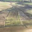
Raddockheugh, settlement and field-system: aerial view. |
19/8/1981 |
Item Level |
|
|
Manuscripts |
MS 712/36 |
Records of Aberdeenshire Archaeology Service, Aberdeen, Scotland |
Photocopies of updates to Aberdeenshire Archaeological Service (formerly Grampian Regional Council) SMR, relating to sites, finds and monuments within area of former Grampian Region, received April 1997 (with supplementary information and covering letter). |
1997 |
Item Level |
|
 |
On-line Digital Images |
DP 189260 |
RCAHMS Aerial Photography Digital |
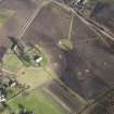
Oblique aerial view of Dykeside farm and the site of the Birnie and Paddockhaugh settlements and the modern pig farm, looking WNW. |
19/2/2014 |
Item Level |
|
 |
On-line Digital Images |
DP 189262 |
RCAHMS Aerial Photography Digital |
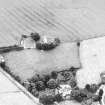
Oblique aerial view of Birnie Parish Church and cemetery, looking NNE. |
19/2/2014 |
Item Level |
|
 |
On-line Digital Images |
SC 1937222 |
Records of Aberdeen Aerial Surveys, Aberdeen, Scotland |
Raddockheugh, settlement and field-system: aerial view. |
19/8/1981 |
Item Level |
|
 |
On-line Digital Images |
SC 2370331 |
Records of the Ordnance Survey, Southampton, Hampshire, England |
Paddockhaugh, NJ25NW 17, Ordnance Survey index card, Recto |
c. 1958 |
Item Level |
|
 |
On-line Digital Images |
SC 2370332 |
Records of the Ordnance Survey, Southampton, Hampshire, England |
Paddockhaugh, NJ25NW 17, Ordnance Survey index card, Recto |
c. 1958 |
Item Level |
|


