
Charlie's Sike


Lade (19th Century)
Site Name Charlie's Sike
Classification Lade (19th Century)
Canmore ID 163002
Site Number NY48NE 172.01
NGR NY 4728 8859
NGR Description NY 4506 8881 to NY 4805 8770
Datum OSGB36 - NGR
Permalink http://canmore.org.uk/site/163002


- Council Scottish Borders, The
- Parish Castleton
- Former Region Borders
- Former District Roxburgh
- Former County Roxburghshire
Field Visit (13 March 1996)
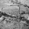
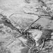
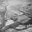
NY48NE 172.01 from 4506 8881 to 4805 8770
The course of the mill-lade is depicted on the 1st edition of the OS 6-inch map (Roxburghshire 1862-3, sheet xlv). The lade is made up partly of natural watercourses and partly of a series of dug channels. From its source, immediately above a caul on the eastward flowing Cauldwell Sike (NY 4506 881), the lade runs for about 2 km in a SSE direction along the foot of Hazelyside Hill. On the 1st edition map, the lade crosses the Annettshiel Burn by an aqueduct at NY c.4553 8852, before joining the upper reaches of the Green Burn. At NY c. 4589 8789, the lade turns NE and runs downhill to the head of the Bedda Cleugh. About 1km down the Bedda Cleugh the lade branches off and extends for a distance of 1.4 km to a series of interconnected ponds and a dam (LID96 34, NY 4800 8773).
Visited by RCAHMS (DCC) 13 March 1996

