|
Manuscripts |
MS 731/20 |
Records of the Royal Commission on the Ancient and Historical Monuments of Scotland (RCAHMS), Edinbu |
Afforestable Land Survey field database (Liddesdale survey, 1996). Held as attribute table in GIS and in Oracle Field/AP table. Please see DX001442 |
1996 |
Item Level |
|
|
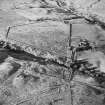
Photographs and Off-line Digital Images |
D 20654 |
RCAHMS Aerial Photography |
Oblique aerial view of Blackburn centred on the remains of a boundary bank with the remains of a lade adjacent, taken from the SE. |
1/12/1997 |
Item Level |
|
|
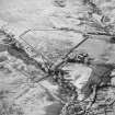
Photographs and Off-line Digital Images |
D 20655 |
RCAHMS Aerial Photography |
Oblique aerial view of Blackburn centred on the remains of a boundary bank with the remains of a lade adjacent, taken from the ESE. |
1/12/1997 |
Item Level |
|
|
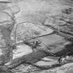
Photographs and Off-line Digital Images |
D 20656 |
RCAHMS Aerial Photography |
Oblique aerial view of Blackburn centred on the remains of a boundary bank with the remains of a lade and a settlement and possible buildings adjacent, taken from the NE. |
1/12/1997 |
Item Level |
|
 |
On-line Digital Images |
SC 1761444 |
RCAHMS Aerial Photography |
Oblique aerial view of Blackburn centred on the remains of a boundary bank with the remains of a lade adjacent, taken from the SE. |
1/12/1997 |
Item Level |
|
 |
On-line Digital Images |
SC 1761445 |
RCAHMS Aerial Photography |
Oblique aerial view of Blackburn centred on the remains of a boundary bank with the remains of a lade adjacent, taken from the ESE. |
1/12/1997 |
Item Level |
|
 |
On-line Digital Images |
SC 1761446 |
RCAHMS Aerial Photography |
Oblique aerial view of Blackburn centred on the remains of a boundary bank with the remains of a lade and a settlement and possible buildings adjacent, taken from the NE. |
1/12/1997 |
Item Level |
|
|
Digital Files (Non-image) |
DX 001442 |
Records of the Royal Commission on the Ancient and Historical Monuments of Scotland (RCAHMS), Edinbu |
RCAHMS Structures Database - Liddesdale survey |
1996 |
Item Level |
|
|
Digital Files (Non-image) |
TM 000559 |
Records of the Royal Commission on the Ancient and Historical Monuments of Scotland (RCAHMS), Edinbu |
Zip file containing all the survey linework collected during the RCAHMS Afforestable Land Survey of Liddesdale |
1996 |
Item Level |
|
|
Digital Files (Non-image) |
TM 002203 |
Records of the Royal Commission on the Ancient and Historical Monuments of Scotland (RCAHMS), Edinbu |
Zip file containing all the survey linework collected during the RCAHMS Afforestable Land Survey of Liddesdale. SHP and Geojson file formats with extra attribution added to the linework. |
1996 |
Item Level |
|


