
Following the launch of trove.scot in February 2025 we are now planning the retiral of some of our webservices. Canmore will be switched off on 24th June 2025. Information about the closure can be found on the HES website: Retiral of HES web services | Historic Environment Scotland
Newbarns Smithy


Field Boundary (19th Century) - (20th Century), Unenclosed Settlement (Prehistoric)
Site Name Newbarns Smithy
Classification Field Boundary (19th Century) - (20th Century), Unenclosed Settlement (Prehistoric)
Canmore ID 161418
Site Number NO64NE 78
NGR NO 67755 49242
Datum OSGB36 - NGR
Permalink http://canmore.org.uk/site/161418


- Council Angus
- Parish Inverkeilor
- Former Region Tayside
- Former District Angus
- Former County Angus
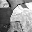
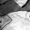
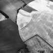
Aerial Photographic Interpretation (23 May 2014)
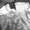
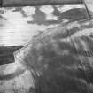
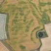
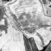
An unenclosed settlement and field boundary have been recorded as cropmarks on oblique aerial photographs (RCAHMSAP 1996) some 120m NW of Newbarns Smithy. The unenclosed settlement comprises a ring ditch and an adjacent circle of pits, both the remains of roundhouses, and further amorphous cropmarks may be the remains of more. The field boundary lies some 30m N of the unenclosed settlement and extends E-W for a distance of about 120m.
Information from RCAHMS (KMM) 23 May 2014

