
Gairlochy, Mucomir Hydro-electric Power Station


Hydroelectric Power Station (Modern)
Site Name Gairlochy, Mucomir Hydro-electric Power Station
Classification Hydroelectric Power Station (Modern)
Alternative Name(s) Mucomir Cut And Bridge; Mucomir Cut; River Lochy; River Spean
Canmore ID 159951
Site Number NN18SE 22
NGR NN 18358 83861
Datum OSGB36 - NGR
Permalink http://canmore.org.uk/site/159951
Ordnance Survey licence number AC0000807262. All rights reserved.
Canmore Disclaimer.
© Bluesky International Limited 2025. Public Sector Viewing Terms
- Correction
- Favourite

SC 493282
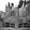
Gairlochy, Hydro-Electric Power Station General View
Papers of Professor John R Hume, economic and industrial historian, Glasgow, Scotland
18/5/1976
© Copyright: HES (Reproduced courtesy of J R Hume)

SC 886176
View from south-west.
Records of the North of Scotland Hydro Electric Board (1943-90), Edinburgh, Scotland
18/12/1960
© Courtesy of HES (Records of the North of Scotland Hydro Electric Board (1943-90), Edinburgh, Scotland)

SC 886253
Reconstruction of bag dam.
Records of the North of Scotland Hydro Electric Board (1943-90), Edinburgh, Scotland
26/6/1959
© Courtesy of HES (Records of the North of Scotland Hydro Electric Board (1943-90), Edinburgh, Scotland)

SC 886291
View of temporary bag-wall looking south-east.
Records of the North of Scotland Hydro Electric Board (1943-90), Edinburgh, Scotland
8/7/1959
© Courtesy of HES (Records of the North of Scotland Hydro Electric Board (1943-90), Edinburgh, Scotland)

SC 886293
Diversion of water through west channel.
Records of the North of Scotland Hydro Electric Board (1943-90), Edinburgh, Scotland
9/7/1959
© Courtesy of HES (Records of the North of Scotland Hydro Electric Board (1943-90), Edinburgh, Scotland)

SC 886364
View of east bank seat for bailey bridge.
Records of the North of Scotland Hydro Electric Board (1943-90), Edinburgh, Scotland
11/9/1958
© Courtesy of HES (Records of the North of Scotland Hydro Electric Board (1943-90), Edinburgh, Scotland)

SC 886427
Trial blast no. 4. Shots being fired.
Records of the North of Scotland Hydro Electric Board (1943-90), Edinburgh, Scotland
1/10/1959
© Courtesy of HES (Records of the North of Scotland Hydro Electric Board (1943-90), Edinburgh, Scotland)

SC 886435
Earth bund being formed behind gabions.
Records of the North of Scotland Hydro Electric Board (1943-90), Edinburgh, Scotland
29/10/1959
© Courtesy of HES (Records of the North of Scotland Hydro Electric Board (1943-90), Edinburgh, Scotland)

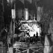
SC 886441
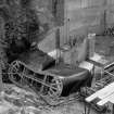
Scale model of generating station.
Records of the North of Scotland Hydro Electric Board (1943-90), Edinburgh, Scotland
2/1960
© Courtesy of HES (Records of the North of Scotland Hydro Electric Board (1943-90), Edinburgh, Scotland)

SC 886489
Collapse of temporary fish pass.
Records of the North of Scotland Hydro Electric Board (1943-90), Edinburgh, Scotland
30/6/1960
© Courtesy of HES (Records of the North of Scotland Hydro Electric Board (1943-90), Edinburgh, Scotland)

DP 023896
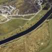
Oblique aerial view centred on the Mucomir Cut, the electricity generating station, bridge, road bridge, farmhouse and farmsteading, taken from the SE.
RCAHMS Aerial Photography Digital
2/4/2007
© Crown Copyright: HES

DP 023900
General oblique aerial view centred on the Mucomir Cut, the electricity generating station, bridge, road bridge, quarry, farmhouse, farmsteading, lock, canal and beacon, taken from the SW.
RCAHMS Aerial Photography Digital
2/4/2007
© Crown Copyright: HES

DP 023901
General oblique aerial view centred on the Mucomir Cut, the electricity generating station, bridge, road bridge, quarry, farmhouse, farmsteading, canal and beacon, taken from the SSW.
RCAHMS Aerial Photography Digital
2/4/2007
© Crown Copyright: HES


SC 886194
Concreting smolt screen piers.
Records of the North of Scotland Hydro Electric Board (1943-90), Edinburgh, Scotland
15/9/1960
© Courtesy of HES (Records of the North of Scotland Hydro Electric Board (1943-90), Edinburgh, Scotland)

SC 886259
View of reconstructed bag dam.
Records of the North of Scotland Hydro Electric Board (1943-90), Edinburgh, Scotland
7/7/1959
© Courtesy of HES (Records of the North of Scotland Hydro Electric Board (1943-90), Edinburgh, Scotland)

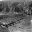
SC 886299
Conditions in Mucomir Cut after breach of bag dam.
Records of the North of Scotland Hydro Electric Board (1943-90), Edinburgh, Scotland
9/6/1959
© Courtesy of HES (Records of the North of Scotland Hydro Electric Board (1943-90), Edinburgh, Scotland)

SC 886416
Reinforced concrete strut under construction.
Records of the North of Scotland Hydro Electric Board (1943-90), Edinburgh, Scotland
31/8/1959
© Courtesy of HES (Records of the North of Scotland Hydro Electric Board (1943-90), Edinburgh, Scotland)

SC 886439
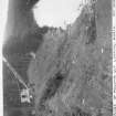
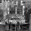
Rock excavation for headrace, generating station and tailrace.
Records of the North of Scotland Hydro Electric Board (1943-90), Edinburgh, Scotland
25/1/1960
© Courtesy of HES (Records of the North of Scotland Hydro Electric Board (1943-90), Edinburgh, Scotland)

SC 886481
General view of site looking south-east.
Records of the North of Scotland Hydro Electric Board (1943-90), Edinburgh, Scotland
1/5/1960
© Courtesy of HES (Records of the North of Scotland Hydro Electric Board (1943-90), Edinburgh, Scotland)

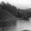
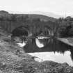
SC 886499
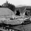
Mucomir Bridge looking east.
Records of the North of Scotland Hydro Electric Board (1943-90), Edinburgh, Scotland
13/5/1959
© Courtesy of HES (Records of the North of Scotland Hydro Electric Board (1943-90), Edinburgh, Scotland)

DP 023894
Oblique aerial view centred on the Mucomir Cut, the electricity generating station, bridge, road bridge, farmhouse and farmsteading, taken from the S.
RCAHMS Aerial Photography Digital
2/4/2007
© Crown Copyright: HES

SC 886271
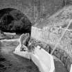
Temporary fish pass south of Mucomir Bridge after modification.
Records of the North of Scotland Hydro Electric Board (1943-90), Edinburgh, Scotland
20/5/1959
© Courtesy of HES (Records of the North of Scotland Hydro Electric Board (1943-90), Edinburgh, Scotland)

SC 886370
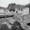
West bank of Mucomir Cut looking north.
Records of the North of Scotland Hydro Electric Board (1943-90), Edinburgh, Scotland
31/7/1958
© Courtesy of HES (Records of the North of Scotland Hydro Electric Board (1943-90), Edinburgh, Scotland)

SC 886491
Draft tube shutter being positioned.
Records of the North of Scotland Hydro Electric Board (1943-90), Edinburgh, Scotland
18/8/1960
© Courtesy of HES (Records of the North of Scotland Hydro Electric Board (1943-90), Edinburgh, Scotland)

DP 023895
Oblique aerial view centred on the Mucomir Cut, the electricity generating station, bridge, road bridge, beacon, farmhouse and farmsteading, taken from the NE.
RCAHMS Aerial Photography Digital
2/4/2007
© Crown Copyright: HES

DP 445939
Mucomir Dam and Power Station
Records of the Scottish Cultural Resources Access Network (SCRAN), Edinburgh, Scotland
1/3/2011
© Licensed by Cairns Aitken (Records of the Scottish Cultural Resources Access Network (SCRAN), Edinburgh, Scotland)

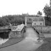
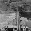
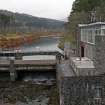
SC 493280
Gairlochy, Hydro-Electric Power Station View across dam
Papers of Professor John R Hume, economic and industrial historian, Glasgow, Scotland
18/5/1976
© Copyright: HES (Reproduced courtesy of J R Hume)

SC 886181
General view of site looking south-west.
Records of the North of Scotland Hydro Electric Board (1943-90), Edinburgh, Scotland
14/11/1960
© Courtesy of HES (Records of the North of Scotland Hydro Electric Board (1943-90), Edinburgh, Scotland)

SC 886200
Head race channel looking south.
Records of the North of Scotland Hydro Electric Board (1943-90), Edinburgh, Scotland
15/9/1960
© Courtesy of HES (Records of the North of Scotland Hydro Electric Board (1943-90), Edinburgh, Scotland)

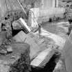
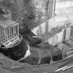
SC 886211
Construction of draft tube
Records of the North of Scotland Hydro Electric Board (1943-90), Edinburgh, Scotland
7/9/1960
© Courtesy of HES (Records of the North of Scotland Hydro Electric Board (1943-90), Edinburgh, Scotland)

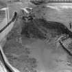
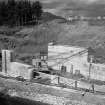
SC 886414
Generating station, headrace and tailrace channel being excavated.
Records of the North of Scotland Hydro Electric Board (1943-90), Edinburgh, Scotland
20/8/1959
© Courtesy of HES (Records of the North of Scotland Hydro Electric Board (1943-90), Edinburgh, Scotland)

SC 886443
Rockslide in sump south of Mucomir Bridge.
Records of the North of Scotland Hydro Electric Board (1943-90), Edinburgh, Scotland
22/2/1960
© Courtesy of HES (Records of the North of Scotland Hydro Electric Board (1943-90), Edinburgh, Scotland)

SC 886487
Collapse of temporary fish pass.
Records of the North of Scotland Hydro Electric Board (1943-90), Edinburgh, Scotland
30/6/1960
© Courtesy of HES (Records of the North of Scotland Hydro Electric Board (1943-90), Edinburgh, Scotland)

SC 886495
Draft tube shutter.
Records of the North of Scotland Hydro Electric Board (1943-90), Edinburgh, Scotland
18/8/1960
© Courtesy of HES (Records of the North of Scotland Hydro Electric Board (1943-90), Edinburgh, Scotland)

DP 023902
General oblique aerial view centred on the Mucomir Cut, the electricity generating station, bridge, road bridge, beacon, farmhouse and farmsteading, taken from the SSW.
RCAHMS Aerial Photography Digital
2/4/2007
© Crown Copyright: HES


DP 445940
Mucomir Dam and Power Station
Records of the Scottish Cultural Resources Access Network (SCRAN), Edinburgh, Scotland
1/3/2011
© Licensed by Cairns Aitken (Records of the Scottish Cultural Resources Access Network (SCRAN), Edinburgh, Scotland)

SC 886173
Diversion under way.
Records of the North of Scotland Hydro Electric Board (1943-90), Edinburgh, Scotland
18/12/1960
© Courtesy of HES (Records of the North of Scotland Hydro Electric Board (1943-90), Edinburgh, Scotland)

SC 886185
Construction of smolt screen piers complete.
Records of the North of Scotland Hydro Electric Board (1943-90), Edinburgh, Scotland
24/10/1960
© Courtesy of HES (Records of the North of Scotland Hydro Electric Board (1943-90), Edinburgh, Scotland)

SC 886214
Concreting draft tube.
Records of the North of Scotland Hydro Electric Board (1943-90), Edinburgh, Scotland
7/9/1960
© Courtesy of HES (Records of the North of Scotland Hydro Electric Board (1943-90), Edinburgh, Scotland)

SC 886265
East end of Mucomir Bridge looking east.
Records of the North of Scotland Hydro Electric Board (1943-90), Edinburgh, Scotland
29/5/1959
© Courtesy of HES (Records of the North of Scotland Hydro Electric Board (1943-90), Edinburgh, Scotland)

SC 886295
Diversion of water through west channel.
Records of the North of Scotland Hydro Electric Board (1943-90), Edinburgh, Scotland
9/7/1959
© Courtesy of HES (Records of the North of Scotland Hydro Electric Board (1943-90), Edinburgh, Scotland)

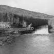
SC 886366
East bank of Mucomir Cut showing proposed site of generating station.
Records of the North of Scotland Hydro Electric Board (1943-90), Edinburgh, Scotland
15/8/1958
© Courtesy of HES (Records of the North of Scotland Hydro Electric Board (1943-90), Edinburgh, Scotland)

SC 886418
Trial blast no. 4. Holes charged and blasting nets in position.
Records of the North of Scotland Hydro Electric Board (1943-90), Edinburgh, Scotland
1/10/1959
© Courtesy of HES (Records of the North of Scotland Hydro Electric Board (1943-90), Edinburgh, Scotland)

SC 886437
South end of terrace.
Records of the North of Scotland Hydro Electric Board (1943-90), Edinburgh, Scotland
24/1/1960
© Courtesy of HES (Records of the North of Scotland Hydro Electric Board (1943-90), Edinburgh, Scotland)

SC 886477
General view of site looking east.
Records of the North of Scotland Hydro Electric Board (1943-90), Edinburgh, Scotland
28/4/1960
© Courtesy of HES (Records of the North of Scotland Hydro Electric Board (1943-90), Edinburgh, Scotland)

SC 886485
East intermediate pier of barrage and east headrace wall.
Records of the North of Scotland Hydro Electric Board (1943-90), Edinburgh, Scotland
18/6/1960
© Courtesy of HES (Records of the North of Scotland Hydro Electric Board (1943-90), Edinburgh, Scotland)

SC 886493
Draft tube shutter being positioned, Mucomir hydroelectric power station, Gairlochy.
Records of the North of Scotland Hydro Electric Board (1943-90), Edinburgh, Scotland
18/8/1960
© Courtesy of HES (Records of the North of Scotland Hydro Electric Board (1943-90), Edinburgh, Scotland)

SC 886256
View of temporary bag dam before breach.
Records of the North of Scotland Hydro Electric Board (1943-90), Edinburgh, Scotland
8/6/1959
© Courtesy of HES (Records of the North of Scotland Hydro Electric Board (1943-90), Edinburgh, Scotland)

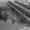
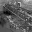
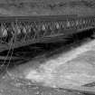
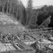
SC 886356
View of bailey bridge looking north-west.
Records of the North of Scotland Hydro Electric Board (1943-90), Edinburgh, Scotland
1/10/1958
© Courtesy of HES (Records of the North of Scotland Hydro Electric Board (1943-90), Edinburgh, Scotland)

SC 886360
Launching of bailey bridge looking east.
Records of the North of Scotland Hydro Electric Board (1943-90), Edinburgh, Scotland
26/9/1958
© Courtesy of HES (Records of the North of Scotland Hydro Electric Board (1943-90), Edinburgh, Scotland)

SC 886472
General view of headrace, generating station and tailrace areas looking south.
Records of the North of Scotland Hydro Electric Board (1943-90), Edinburgh, Scotland
11/4/1960
© Courtesy of HES (Records of the North of Scotland Hydro Electric Board (1943-90), Edinburgh, Scotland)

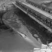
SC 886474
View of tailrace looking north.
Records of the North of Scotland Hydro Electric Board (1943-90), Edinburgh, Scotland
26/4/1960
© Courtesy of HES (Records of the North of Scotland Hydro Electric Board (1943-90), Edinburgh, Scotland)

SC 886479
East lining of tailrace channel nearing completion.
Records of the North of Scotland Hydro Electric Board (1943-90), Edinburgh, Scotland
28/4/1960
© Courtesy of HES (Records of the North of Scotland Hydro Electric Board (1943-90), Edinburgh, Scotland)

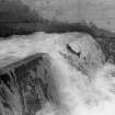
SC 886168
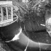
2990 cusecs of water passing through generating station, Mucomir hydroelectric power station, Gairlochy.
Records of the North of Scotland Hydro Electric Board (1943-90), Edinburgh, Scotland
15/2/1961
© Courtesy of HES (Records of the North of Scotland Hydro Electric Board (1943-90), Edinburgh, Scotland)

SC 886288
Diversion of water through west channel.
Records of the North of Scotland Hydro Electric Board (1943-90), Edinburgh, Scotland
9/7/1959
© Courtesy of HES (Records of the North of Scotland Hydro Electric Board (1943-90), Edinburgh, Scotland)

SC 886297
Sea trout negotiating temporary fish pass.
Records of the North of Scotland Hydro Electric Board (1943-90), Edinburgh, Scotland
9/7/1959
© Courtesy of HES (Records of the North of Scotland Hydro Electric Board (1943-90), Edinburgh, Scotland)

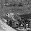
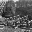
SC 886354
Erection of bailey bridge.
Records of the North of Scotland Hydro Electric Board (1943-90), Edinburgh, Scotland
26/9/1958
© Courtesy of HES (Records of the North of Scotland Hydro Electric Board (1943-90), Edinburgh, Scotland)

SC 886358
Launching of bailey bridge.
Records of the North of Scotland Hydro Electric Board (1943-90), Edinburgh, Scotland
26/9/1958
© Courtesy of HES (Records of the North of Scotland Hydro Electric Board (1943-90), Edinburgh, Scotland)

SC 886431
Trial blast no. 4. View of rock after blasting.
Records of the North of Scotland Hydro Electric Board (1943-90), Edinburgh, Scotland
1/10/1959
© Courtesy of HES (Records of the North of Scotland Hydro Electric Board (1943-90), Edinburgh, Scotland)

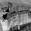
SC 886483
East headrace wall under construction.
Records of the North of Scotland Hydro Electric Board (1943-90), Edinburgh, Scotland
1/5/1960
© Courtesy of HES (Records of the North of Scotland Hydro Electric Board (1943-90), Edinburgh, Scotland)

DP 023898
Oblique aerial view centred on the quarry with the electricity generating station and bridge adjacent, taken from the WNW.
RCAHMS Aerial Photography Digital
2/4/2007
© Crown Copyright: HES

SC 886362
Erection of bailey bridge.
Records of the North of Scotland Hydro Electric Board (1943-90), Edinburgh, Scotland
26/9/1958
© Courtesy of HES (Records of the North of Scotland Hydro Electric Board (1943-90), Edinburgh, Scotland)

SC 886368
Line of west wall looking south.
Records of the North of Scotland Hydro Electric Board (1943-90), Edinburgh, Scotland
31/7/1958
© Courtesy of HES (Records of the North of Scotland Hydro Electric Board (1943-90), Edinburgh, Scotland)

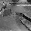
SC 886433
Flood waters seeping through gabion wall into main excavation.
Records of the North of Scotland Hydro Electric Board (1943-90), Edinburgh, Scotland
24/10/1959
© Courtesy of HES (Records of the North of Scotland Hydro Electric Board (1943-90), Edinburgh, Scotland)

SC 886468
Construction of west training wall looking west from Mucomir Bridge.
Records of the North of Scotland Hydro Electric Board (1943-90), Edinburgh, Scotland
21/1/1959
© Courtesy of HES (Records of the North of Scotland Hydro Electric Board (1943-90), Edinburgh, Scotland)

SC 886470
Bored piles in west training wall.
Records of the North of Scotland Hydro Electric Board (1943-90), Edinburgh, Scotland
13/2/1959
© Courtesy of HES (Records of the North of Scotland Hydro Electric Board (1943-90), Edinburgh, Scotland)

SC 886497
Draft tube shutter, Mucomir hydroelectric power station, Gairlochy.
Records of the North of Scotland Hydro Electric Board (1943-90), Edinburgh, Scotland
19/8/1960
© Courtesy of HES (Records of the North of Scotland Hydro Electric Board (1943-90), Edinburgh, Scotland)


- Council Highland
- Parish Kilmonivaig
- Former Region Highland
- Former District Lochaber
- Former County Inverness-shire
NN18SE 22.00 18358 83861
Power Station [NAT]
OS (GIS) AIB, April 2006.
NN18SE 22.01 NN 18330 83859 Bridge (over Mucomir Cut)
NN18SE 22.02 NN 18360 83828 Footbridge (over tail-race)
For associated Mucomir Cut (NN 18395 84479 to NN 18353 83797), see NN18SE 27.00.
Year first commissioned: 1962
Gross head: 23ft [7m]
Installed capacity: 1.95mW
Average annual output: 9 million units
P L Payne 1988.
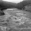
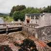
Mucomir Cut, 1951. Power station installed in a channel between the S end of Loch Lochy and the Spean River. Average annual output 9 million units.
J Miller 2002.

