
Kinbuck, Bridge


Road Bridge (18th Century)
Site Name Kinbuck, Bridge
Classification Road Bridge (18th Century)
Alternative Name(s) Allan Water; Kinbuck Bridge
Canmore ID 159762
Site Number NN70NE 31
NGR NN 79123 05384
Datum OSGB36 - NGR
Permalink http://canmore.org.uk/site/159762


- Council Stirling
- Parish Dunblane And Lecropt
- Former Region Central
- Former District Stirling
- Former County Perthshire
NN70NE 31 79123 05384
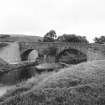
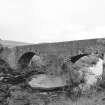
(Location cited as NO 792 053). Bridge, Kinbuck, built 1752. A two-span rubble bridge, with segmental arches and triangular cutwaters. The central pier is now protected by a concrete island, and the wing-walls on the E side have been rebuilt with concrete blocks.
J R Hume 1977.
This bridge carries the B8033 public road over the Allan Water to the N of Kinbuck village (NN70NE 32).
Information from RCAHMS (RJCM), 30 August 2000.

