
Pricing Change
New pricing for orders of material from this site will come into place shortly. Charges for supply of digital images, digitisation on demand, prints and licensing will be altered.
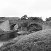
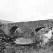
Kinbuck, Bridge


Road Bridge (18th Century)
Site Name Kinbuck, Bridge
Classification Road Bridge (18th Century)
Alternative Name(s) Allan Water; Kinbuck Bridge
Canmore ID 159762
Site Number NN70NE 31
NGR NN 79123 05384
Datum OSGB36 - NGR
Permalink http://canmore.org.uk/site/159762


- Council Stirling
- Parish Dunblane And Lecropt
- Former Region Central
- Former District Stirling
- Former County Perthshire
NN70NE 31 79123 05384
(Location cited as NO 792 053). Bridge, Kinbuck, built 1752. A two-span rubble bridge, with segmental arches and triangular cutwaters. The central pier is now protected by a concrete island, and the wing-walls on the E side have been rebuilt with concrete blocks.
J R Hume 1977.
This bridge carries the B8033 public road over the Allan Water to the N of Kinbuck village (NN70NE 32).
Information from RCAHMS (RJCM), 30 August 2000.

