
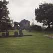
Kinloss Abbey And Burial Ground


Abbey (Medieval), Burial Ground (Medieval), Carved Stone(S) (Period Unknown), Pot (12th Century) - (15th Century)
Site Name Kinloss Abbey And Burial Ground
Classification Abbey (Medieval), Burial Ground (Medieval), Carved Stone(S) (Period Unknown), Pot (12th Century) - (15th Century)
Canmore ID 15888
Site Number NJ06SE 2
NGR NJ 06570 61507
Datum OSGB36 - NGR
Permalink http://canmore.org.uk/site/15888


First 100 images shown. See the Collections panel (below) for a link to all digital images.
- Council Moray
- Parish Kinloss
- Former Region Grampian
- Former District Moray
- Former County Morayshire
NJ06SE 2.00 06570 61507
NJ06SE 2.01 06572 61467 Abbot's Lodging
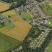
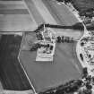
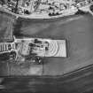
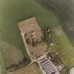
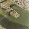
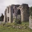
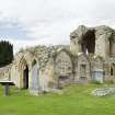
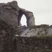
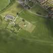
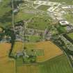
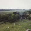
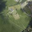
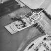
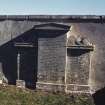
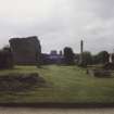
(NJ 0655 6150) Kinloss Abbey (NR) (Ruins)
OS 6" map (1938)
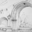
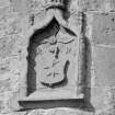
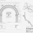
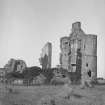
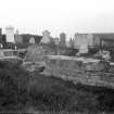
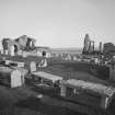
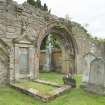
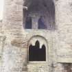
Founded in 1150 and dedicated to St Mary the abbey was greatly added to about 1530. The abbot's house was erected in 1537. In the south wall of the cloister is an archway, and an adjoining arched recess, which seem from their style to be part of the original abbey.
The buildings are thought to have been reasonably entire until about 1650, when they are said to have been sold for the building of Cromwell's Fort at Inverness.
D MacGibbon and T Ross 1896
Kinloss Abbey, a Cistercian foundation, by David I, of monks from Melrose. There is doubt as to whether the date of foundation is 21st May 1150 (Chron Melrose 1835) or 1151 (J Stuart 1872; A O Anderson 1922). The abbey was erected into a temporal lordship in 1601.
D E Easson 1957
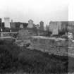
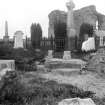
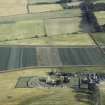
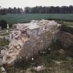
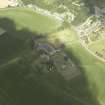
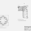
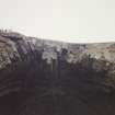
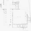
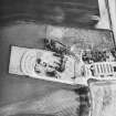
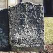
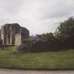
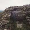
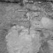
Generally as described and planned by MacGibbon and Ross. The bases of some pillars and part of the walling of the abbey church are now exposed and much of its outline can be conjectured indicating a building some 52.0m east to west and about 35.0m North-South across the transepts. The plan of the church is however partly obscured and greatly confused by the graves and remains of old vaults of the cemetery that now occupies this site.
The area immediately West of the cloisters is slightly raised above the adjoining ground and may possibly represents the remains of other buildings associated with the abbey.
Part-revised at 25".
Visited by OS (RDL) 16 September 1963.
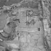
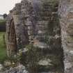
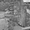
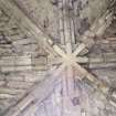
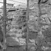
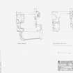
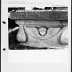
NJ 065 615 As part of a programme of masonry consolidation, the concrete capping had been removed from the upper floors of the N and S wings of the post-monastic building atop the N end of the partially ruined E range of the abbey. The exposed features were investigated and recorded by Scotia Archaeology Limited.
In the first storey of the N wing of the building the flagged floor was reasonably intact and there was slight evidence of a hearth in the NW corner of the room. The floor was pierced on its E side by what was probably the chute of a slop drain. The original stair, on the W side of the building, had been replaced in recent times by another stair, built on a slightly different alignment. Most of the flags were missing from the second floor of the S wing which was probably entered by a doorway in its NW corner.
Sponsor: Moray District Council.
J Lewis 1995.
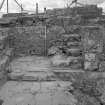
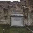
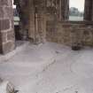
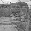
NJ 065 614 Supervision of rubble clearance at the Abbot's House, as part of consolidation works, was carried out in February 1996. Access to the site was cleared and all architectural stone was isolated for future reuse. A reredorter drain was further exposed and structural evidence confirming that the Abbot's House is a later addition to the Abbey was found. A slight deviation in the N wall of the Abbot's House was also uncovered at the point where two vaults meet. This provided further evidence that there was an earlier wall incorporated into the gable of the Abbot's House.
Sponsor: Moray District Council
J R Mackenzie 1996
NJ 0655 6150 In June 2006 the installation of three interpretation panels around the abbey required the hand excavation of three 700mm squares to a depth of 200mm. The excavation of one of these squares, which was just inside the W wall of the abbey church, revealed a small section of mortared stonework comprising dressed sandstone blocks. This was recorded and covered and the position of the panel was moved to avoid it.
Report lodged with Aberdeenshire SMR and NMRS.
Sponsor: Kinloss Abbey Trust.
H K Murray and J C Murray, 2006.
NJ06SE 2.00 06570 61507
NMRS REFERENCE:
Begun in 1150 on the lines of a Cistercian Monastry. Represents many periods of architecture, of which portions remain and part has still its vaulted roof. Situated about two miles NE of Forres.
Note: Nesbit was a painter at Forres, 1866.
EXTERNAL REFERENCE:
National Library of Scotland, Nattes Drawings - 2 drawings
Vol I nos 14, 15
"Uncatalogued MSS of General Hutton", vol 11, no. 41 - plan by Nesbit, Scale 30 feet to an inch.
The National Library of Scotland, Edinburgh, contains in "MSS. 3294-5" vol II, or 3295, and illustrating a Tour in the East of Scotland made by James Bailey in 1787, a Frontispiece showing a View of 'kynloss' Abbey, near Forres, in the Shire of Moray. (see page 29 of the volume).
Scottish National Portrait Gallery - S.M.T. Magazine for Dec 1950 - Article and photographs
Antiquarian Observation (1857 - 1861)
Mason's marks from Scottish churches, abbeys and castles recorded between 1857 and 1861 on 29 drawings in the Society of Antiquaries of Scotland Collection.
Watching Brief (23 September 1997)
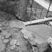
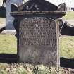
NJ 065 615 An archaeological watching brief was completed by Kirkdale Archaeology during the opening of a new grave in the family plot of the Dunbar-Naismith family at Kinloss Abbey in September 1997.
The family burial plot lies against the S side of the S cloister wall, believed to be a part of the original abbey, built c 1150/1. The plot is defined by three ashlar walls, forming a rectangular area 5.8m N-S by 4.6m E-W abutting the S side of the S cloister wall, and accessed via an original arch in the latter. Before the most recent interment, the plot held three graves against its S wall, and a further two (in the same grave) against the W wall, running E-W.
The new grave was located in the NE corner, against the burial plot E wall and the S cloister wall. Excavation to a depth of 1.75m revealed the brick lining of the E-W grave, constructed in 1905, and the ashlar founds of the plot boundary wall, also to the full depth of the trench. No monastic material was recovered, and the depth of the founds of the boundary wall, coupled with the density and depth of graves within the plot, would suggest that any monastic remains will have been removed in the 19th century, when the family plot was first laid out.
Sponsor: Historic Scotland
G Ewart and A Dunn 1997
Watching Brief (June 2006)
NJ 0655 6150 In June 2006 the installation of three interpretation panels around the abbey required the hand excavation of three 700mm squares to a depth of 200mm. The excavation of one of these squares, which was just inside the W wall of the abbey church, revealed a small section of mortared stonework comprising dressed sandstone blocks. This was recorded and covered and the position of the panel was moved to avoid it.
Report lodged with Aberdeenshire SMR and NMRS.
Sponsor: Kinloss Abbey Trust.
H K Murray and H C Murray 2006
Earth Resistance Survey (7 July 2012)
NJ 06500 61400 Earth resistance survey was undertaken over two small areas amongst the ruins of Kinloss Abbey, Moray, as part of the Rekindle Kinloss community project. A line of Electrical Resistivity Tomography data was also gathered. The Rekindle Kinloss project is a year long Heritage Lottery Funded project aimed at those aged 13 to 25. Through a variety of activities and workshops, the aim of the work is to help participants engage with their local heritage and encourage a sense of community. The geophysical survey reported here was another aspect of the project and was intended to allow the project participants a hands-on experience of collecting their own geophysical survey data. The intention was, by choosing a technique which can be undertaken by anyone with supervision, that the volunteers would be able to take ownership of the survey and by extension, of the area investigated. It was also hoped that the work, although primarily a training exercise, would produce results which aided the understanding and interpretation of the Abbey site.
Because the areas investigated were so small, interpretation of the earth resistance data is not straightforward, however, the results do suggest the presence of underlying structural material such as rubble and wall lines. The possible wall lines in Area 2 (see Figure 2) are likely to relate to the location of the Chapter House and to Cloister Walls. The results in Area 1, within the Abbots’ House (see Figure 2), are on a different orientation than the extant remains which again makes interpretation difficult. These anomalies could represent the presence of internal features or may merely be large spreads of rubble remaining within the limits of the building. The line of ERT (Electrical Resistivity Tomography) in Area 2 (see Figure 3) shows one extremely distinctive area of high resistivity and it seems most likely that this relates to an extension of the foundations of the outer cloister wall.
Information from OASIS ID: orkneyre1-514837 (M J Saunders) 2012
Photographic Survey (13 June 2013)
Photographed on behalf of the Buildings of Scotland publications 2013-14.
Watching Brief (5 December 2019 - 13 March 2020)
NJ 06554 61460 A programme of archaeological mitigation entailing a watching brief and limited recording was commissioned by Kinloss Abbey Trust to monitor stabilisation works of the Abbot’s House, part of the Scheduled Monument (SM1227) Kinloss Abbey.
The mitigation was designed to monitor works to ensure that the historic fabric of the structure was not damaged during the works and that the limited ground-breaking that was required was undertaken under archaeological supervision. A mitigation strategy was approved in advance by HES.
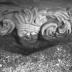
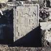
The excavation work under two surviving vaults on the W side of the Abbot’s House revealed mixed modern disturbed material with some historic debris. A single piece of Scottish Redware ceramic dating to between the 12th and 15th century was recovered. Where tumbled stones needed to be moved this was also monitored, and some quality carved pieces were noted. All stone was stored on site. As no in situ deposits were found and the finds were sparse and scattered, no further work beyond standard reporting and archiving is recommended.
Archive: Aberdeenshire HER and NRHE
Funder: Kinloss Abbey Trust
Knockando
Lachlan McKeggie – Highland Archaeology Services
(Source: DES Volume 21)

