
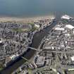
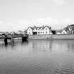
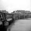
Ayr, Harbour Branch Bridge


Railway Viaduct (19th Century) - (20th Century)
Site Name Ayr, Harbour Branch Bridge
Classification Railway Viaduct (19th Century) - (20th Century)
Alternative Name(s) River Ayr; Harbour Branch Viaduct
Canmore ID 158791
Site Number NS32SW 151
NGR NS 33651 22234
Datum OSGB36 - NGR
Permalink http://canmore.org.uk/site/158791


- Council South Ayrshire
- Parish Ayr
- Former Region Strathclyde
- Former District Kyle And Carrick
- Former County Ayrshire
NS32SW 151 33651 22234
Location formerly cited as NS 3365 2224.
Viaduct [NAT]
OS 1:10,000 map, 1978.
(Location cited as NS 337 223). Harbour Branch Bridge, built 1899 for the Glasgow and South Western Rly. A 5-span steel bridge on a curve, with rivetted parallel truss spans supported on pairs of circular stone piers, one of which has been replaced in brick.
J R Hume 1976.
The location assigned to this record defines the approximate midpoint of this curving stricture. The current edition of the OS (GIS) 1:2500 scale digital map depicts the pairs of piers extending across the River Ayr between NS c. 33693 22270 and NS c. 33604 22212.
Information from RCAHMS (RJCM), 19 May 2006.

