
Stirling, Raploch Aerodrome


Military Airfield (First World War)
Site Name Stirling, Raploch Aerodrome
Classification Military Airfield (First World War)
Alternative Name(s) Falleninch
Canmore ID 158587
Site Number NS79SE 212
NGR NS 7809 9396
NGR Description Centred NS 7809 9496
Datum OSGB36 - NGR
Permalink http://canmore.org.uk/site/158587


- Council Stirling
- Parish Stirling
- Former Region Central
- Former District Stirling
- Former County Stirlingshire
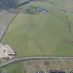
Stirling (Raploch) landing ground was built in the Spring of 1916 on an area of low-lying ground north of Stirling King’s Park and west of the castle. It extended to an area of 48 hectares (measuring a maximum of 1250m by 490m) centred on Fallinch Farm, the buildings of which were requisitioned for military use. Wooden hangars were built for the aircraft while the other technical buildings and the accommodation were of canvas. No. 18 Reserve Squadron at Montrose provided a nucleus for the formation of No. 43 Squadron at Stirling, the aim of which was to train to a high enough standard to go to France before the end of the year. Raploch was used for training by other squadrons until the autumn of 1917, when purpose-built training aerodromes began to take over that role. It also served as an emergency landing ground for No. 77 Home Defence Squadron. It was occasionally used for civil landings between the wars but was not re-occupied in the Second World War. Nothing survives of the landing ground.
Information from HS/RCAHMS World War One Audit Project (GJB) 31 May 2013
NS79SE 212 centred 7809 9396
For Falleninch Farmstead See also NS79SE 241
In area now enclosed by the M9, A84 and A811 roads is the site of a First World War airfield. No remains of the airfield could be found on the date of visit.
J Guy 1999; D J Smith; NMRS MS 810/7, 17-18
First World War aerodrome situated in the fields around Falleninch Farmsteading (NS79SE 241).
Opened in 1916 and used for training pilots, the farmhouse at Falleninch being requisitioned for miltary use. The aerodrome occupied about 43 hectares and was bounded by the Raploch Burn (now a boundary fence), to the S and the Forth to Clyde Railway (now abandoned, the trackbed surviving), on the N. To assist with flying operations the telegraph poles along the railway were cut shorter.
Information from RCAHMS (DE), August 2007; M Fife 2007.
Project (March 2013 - September 2013)
A project to characterise the quantity and quality of the Scottish resource of known surviving remains of the First World War. Carried out in partnership between Historic Scotland and RCAHMS.

