
Altyre House


Cross Slab (Early Medieval), Ogham Inscribed Stone (Early Medieval)
Site Name Altyre House
Classification Cross Slab (Early Medieval), Ogham Inscribed Stone (Early Medieval)
Canmore ID 15812
Site Number NJ05NW 34
NGR NJ 0391 5537
Datum OSGB36 - NGR
Permalink http://canmore.org.uk/site/15812


- Council Moray
- Parish Rafford
- Former Region Grampian
- Former District Moray
- Former County Morayshire
Altyre, Moray, ogham-inscribed cross-slab
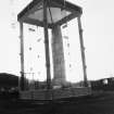
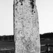
Measurements: H 3.30m above ground, W 0.86m, D 0.18m
Stone type: grey sandstone
Place of discovery: NJ c 141 641
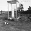
Present location: within an enclosure in a field to the west of the site of the old kirk of Altyre at NJ 0391 5537.
Evidence for discovery: recorded as standing on rising ground in a field belonging to Longhillock Farm and moved around 1800 to a field north of Altyre House.
Present condition: severely weathered and there is considerable edge damage.
Description
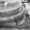
A very tall and slender slab, this formerly bore a plain cross with a small head and very long shaft carved in relief on both broad faces, but the cross-head on face C has eroded away, leaving only the shaft. At the base of the shaft are traces of a stepped base.
Face A is bordered by an incised line to give the impression of a moulding, but the weathering of face C makes it impossible to tell whether this side also had a border. The cross on face A has stepped armpits, hammer-head side-arms and a square or rectangular upper arm, which survives only partially. The shaft is bordered by an incised line. Running up face D is a long ogham inscription with the letters arranged on an incised stem-line, but its weathered state makes interpretation difficult, indeed even its language, whether Irish or Pictish, is uncertain.
Date: late eighth or ninth century
References: Calder & Jackson 1957; Forsyth 1996, 23-40; Bennett 1999, 18-20.
Desk-based information compiled by A Ritchie 2018
Field Visit (16 August 1965)
This Ogham-inscribed cross-slab is as described above. It is 3.3m high from the present ground level, and is surrounded by a wooden fence.
Revised at 25".
Visited by OS (NKB) 16 August 1965
Desk Based Assessment
NJ05NW 34 0391 5537
See also NJ16NW 20.
(NJ 0391 5537) Sculptured Stone (NR) Runic
OS 6" map (1938)
The sandstone pillar, at Altyre, was brought there from the Laich, probably about 1820. According to the late H W Young of Elgin it came from the college field at the village of Rose isle (J R Allen and J Anderson 1903). Traditionally this stone is confused with a monument (Moray 6 SE 6) erected to commemorate the defeat of King Duncan by Thorfinn in 1040, or a victory won by Malcolm II over Camus the Dane. The Altyre stone is at least two centuries older than King Duncan. Its total height is given by Stuart as 15ft; slightly over 11ft now appears above ground level. It is 34in wide and 7in thick. The cross on the front is still partially preserved. Only the vertical beam remains of that on the back. The Ogham inscription on the slightly recessed flat of the undressed left side is 49in long and reaches up to a point 5ft from the summit. It reads AMMAQQAAHALIMVBVMA (?) AHHRRSSUDDS or AMMAQQADALLMVBVMA (?) AHHRRSSUDDS. Its meaning is unknown.
Information from OS
W M Calder and K Jackson 1959; J Stuart 1856

