
Burgie Castle


Tower House (Medieval)
Site Name Burgie Castle
Classification Tower House (Medieval)
Alternative Name(s) Burgie Tower
Canmore ID 15765
Site Number NJ05NE 1
NGR NJ 09368 59314
Datum OSGB36 - NGR
Permalink http://canmore.org.uk/site/15765


First 100 images shown. See the Collections panel (below) for a link to all digital images.
- Council Moray
- Parish Rafford
- Former Region Grampian
- Former District Moray
- Former County Morayshire
NJ05NE 1.00 09368 59314
NJ05NE 1.01 09331 59299 Dovecot
For (successor) Burgie House (NJ 0903 5948) and dependant buildings, see NJ05NE 14.00.
(NJ 0937 5931) Burgie Castle (NR) (Remains of)
OS 6" map (1906)
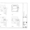
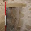
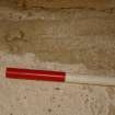
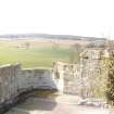
Burgie Castle: This is a well-preserved square tower, which formed part of a larger bulding on the Z-plan, of which the greater part is now removed. The plan shows the probable outline of the main block.
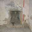
The north west tower and a portion of the main block are the only part of the building now remaining. In the fragment of the main block still left is the fireplace; with above it the coat of arms of the Dunbars, its founders, and the date 1602; its date of foundation.
The building above to the right in Nattes' sketch (J C Nattes unpublished sketches c.1799) is evidently a later addition.
D MacGibbon and T Ross 1887
To the west of the tower, by the entrance to the gardens is a dovecot (NJ05NE 1.01) measuring 19 x 17 feet. The small doors and thick walls indicate a dovecot of the old type. No date is visible.
R Douglas 1931
Burgie Castle, and the dovecot (NJ05NE 1.01) at NJ 0932 5929, are as described above. Above the door of the dovecot is an opening similar to those found in the Findrassie and Leuchars dovecots, the former of which bears the date 1631.
Castle revised at 25".
Visited by OS (RD) 6 August 1965.
Burgie Castle [NR]
OS 1:10,000 map, 1975.
Horse-exercising area noted.
NMRS, MS/712/17.
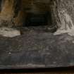
Burgie Castle: impressive square tower which formed part of a larger Z-plan building which was formerly of six storeys; in the main block there is a fireplace with above it the coat of arms of the Dunbars (its founders) and the date 1602 (its date of foundation). There is a true yett at the basement entrance and a superb stone-lined well of curved ashlar construction about 6m S of the NW tower; the conical cover of this feature is broken. The greater part of the building was demolished about 1800 to provide material for Burgie House (NJ05NE 14.00), leaving the NW tower and part of the main block standing.
NMRS, MS/712/19.
EXTERNAL REFERENCE:
National Library. Nattes Drawings - 2 drawings, Oct 15th, vol. 1, nos. 10 & 17
Photographic Survey (21 April 2008 - 6 May 2008)
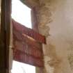
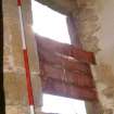
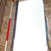
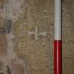
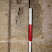
NJ 0936 5931 Burgie Castle is the tower of a former tower house which is both scheduled and listed. A very similar tower house not far away, Blervie, collapsed about three years ago and Burgie was in imminent danger until the present stabilisation work. Major vertical cracks had appeared in the fabric, the roof was in very poor condition and mortar had failed in the walls at roof level. Work undertaken from 21 April–6 May 2008 accompanied emergency works by the Highland Buildings Preservation Trust to stabilise the building until a conservation project can be developed. A rapid photographic record was made of the building itself. The watching brief covered the opening of a small number of pits to form the bases for supporting scaffolding. 98% of the excavations were monitored.
Archive: HAS Office
Funder: Captain Hamish Lochore
Brendan Malone (Highland Archaeology Services Ltd), 2008
Note
Burgie castle was built for Robert Dunbar in about 1602. The majority of the castle, apart from the tower and fragment of the main block, was demolished in 1802 and its building materials re-used elsewhere. The Dunbar family also constructed nearby Blervie Castle around the same time, and almost to the same plan. Again, only a fragment of that castle survives and it has recently suffered a major collapse.
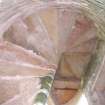
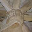
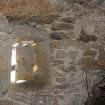
The Castle consists of a single corner tower of a large-scale Z-plan fortified house, together with an adjoining portion the main block. The rest of the castle has been demolished, but is known from a drawing by John Claude Nattes of 1799. Between the tower and surviving fragment of the main block is a corbelled-out spiral stair that gives access to the upper floors.
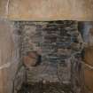
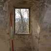
The six-storeyed tower has a crenellated and turreted wall head with water spouts in the form of cannon. At first floor level, within the surviving fragment of the main block, is the hall fireplace which has a joggled lintel decorated with the arms of the Dunbar family and the date 1602.
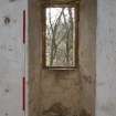
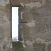
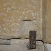
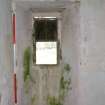
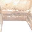
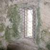
Each storey in the tower has a single room, of these the basement, the two upper storeys and the apex of the stair tower are all vaulted. Although only a fragment of the castle survives, what remains demonstrates workmanship of the highest quality. The section of the castle which has escaped demolition has also retained a number of important details and finishes. Extensive areas of plaster remain on the internal walls, while timberwork, including floors, cornice, doors and a shuttered window, also survive. Surviving ironwork includes a wrought iron yett and window grills at first floor level.
D MacGibbon and T Ross 1887; N Tranter 1970
Information from the HES Castle Conservation Register, 5 July 2022

