
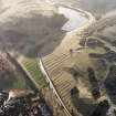
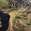
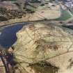
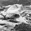
Edinburgh, Holyrood Park, Dunsapie Craig


Ring Ditch (Period Unassigned)
Site Name Edinburgh, Holyrood Park, Dunsapie Craig
Classification Ring Ditch (Period Unassigned)
Alternative Name(s) Queen's Park; Whinny Hill
Canmore ID 157292
Site Number NT27SE 3976
NGR NT 28293 73447
Datum OSGB36 - NGR
Permalink http://canmore.org.uk/site/157292


- Council Edinburgh, City Of
- Parish Edinburgh (Edinburgh, City Of)
- Former Region Lothian
- Former District City Of Edinburgh
- Former County Midlothian
Field Visit (15 December 1998)
NT27SE 3976 2829 7344
See also NT27SE 3942.
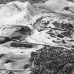
A small ring-ditch is situated immediately within the Park wall and appears to overlie rig-and-furrow cultivation (NT27SE 3942). It measures 6.8m in diameter over a ditch 1.7m in width and 0.15m in depth. It is plotted on an archaeological map of Holyrood Park (RCAHMS 1999).
Visited by RCAHMS (ARG), 15 December 1998.
RCAHMS 1999.

