
Pricing Change
New pricing for orders of material from this site will come into place shortly. Charges for supply of digital images, digitisation on demand, prints and licensing will be altered.
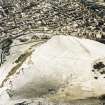
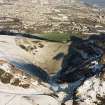
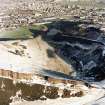
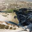
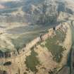
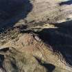
Edinburgh, Holyrood Park, Hunter's Bog


Enclosure (Period Unassigned)
Site Name Edinburgh, Holyrood Park, Hunter's Bog
Classification Enclosure (Period Unassigned)
Alternative Name(s) Queen's Park
Canmore ID 157267
Site Number NT27SE 3956
NGR NT 2733 7319
NGR Description Centred NT 2733 7319
Datum OSGB36 - NGR
Permalink http://canmore.org.uk/site/157267


- Council Edinburgh, City Of
- Parish Edinburgh (Edinburgh, City Of)
- Former Region Lothian
- Former District City Of Edinburgh
- Former County Midlothian
NT27SE 3956 centred 2733 7319
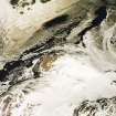
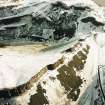
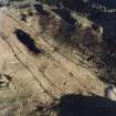
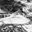
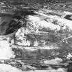
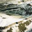
A cultural heritage survey of Holyrood Park, Edinburgh, was undertaken in February 1996. The survey was designed to identify and evaluate the archaeological remains present withing Holyrood Park, through the examination of desk-based sources and a field inspection. A large number of sites were already recorded within the park and are listed in the NMRS. The following list is of sites not previously recorded (excluding rig and furrow and unassociated field banks), the majority of which relate to quarrying activities or are features associated with 19th-century use and management of the park.
NT 2733 7320 Enclosure.
A full report will be lodged with the NMRS.
Sponsor: Historic Scotland
D Alexander 1996.
Field Visit (15 December 1998)
An enclosure lies at the foot of the steep slope on the SE side of Hunter's Bog. It measures 41.5m from N to S by 38.2m transversely within a stony bank 1.8m in thickness and 0.4m in height. A bank extends the W side N for 4.8m from the NW corner, before turning upslope parallel with the N end of the enclosure for 16.3m. A footpath skirts along the W side of the enclosure. The enclosure is annotated as an 'old fence' on the OS 1:1056 map in 1854 (Edinburgh and its environs 1854, sheet 37), and is plotted at 1:5,550 on an archaeological map of Holyrood Park (RCAHMS 1999).
Visited by RCAHMS (ARG), 15 December 1998.
NMRS, MS/726/96 (76, no. 87); RCAHMS 1999.

