
Pricing Change
New pricing for orders of material from this site will come into place shortly. Charges for supply of digital images, digitisation on demand, prints and licensing will be altered.
Scheduled Maintenance Notice
Please be advised that this website will undergo scheduled maintenance starting on Thursday, 30th January at 11:00 AM and will last until Friday, 31st January at 10:00 AM.
During this time, the site and certain functions may be partially or fully unavailable. We apologise for any inconvenience this may cause.
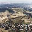
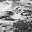
Edinburgh, Holyrood Park, Whinny Hill


Quarry(S) (Period Unassigned), Spring (Period Unassigned)
Site Name Edinburgh, Holyrood Park, Whinny Hill
Classification Quarry(S) (Period Unassigned), Spring (Period Unassigned)
Alternative Name(s) Queen's Park
Canmore ID 157258
Site Number NT27SE 3949
NGR NT 2814 7339
Datum OSGB36 - NGR
Permalink http://canmore.org.uk/site/157258


- Council Edinburgh, City Of
- Parish Edinburgh (Edinburgh, City Of)
- Former Region Lothian
- Former District City Of Edinburgh
- Former County Midlothian
NT27SE 3949 2814 7339
A cultural heritage survey of Holyrood Park, Edinburgh, was undertaken in February 1996. The survey was designed to identify and evaluate the archaeological remains present withing Holyrood Park, through the examination of desk-based sources and a field inspection. A large number of sites were already recorded within the park and are listed in the NMRS. The following list is of sites not previously recorded (excluding rig and furrow and unassociated field banks), the majority of which relate to quarrying activities or are features associated with 19th-century use and management of the park.
NT 2818 7337 Quarry.
NT 2818 7348 Depression.
A full report will be lodged with the NMRS.
Sponsor: Historic Scotland
D Alexander 1996
Field Visit (15 December 1998)
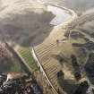
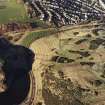
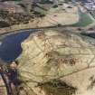
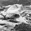
Two quarry-pits are situated low on the SE flank of Whinny Hill above the rig-and-furrow cultivation described under NT27SE 3942. The larger is situated some 120m to the NNE of the N end of Dunsapie Loch, and measures 19.5m from ENE to WSW by 18m transversely and up to 2m in depth; it has a rim of upcast and is plotted at 1:5,550 on an archaeological map of Holyrood Park (RCAHMS 1999). The smaller pit lies about 110m to the NNE, and measures 6m by 2.5m; it is probably no more than an old spring.
Visited by RCAHMS (ARG), 15 December 1998.
NMRS, MS/726/96 (65-6 and 80, nos. 62 and 96); RCAHMS 1999.

