
Edinburgh, Holyrood Park, Whinny Hill


Rig And Furrow (Medieval) - (Post Medieval)
Site Name Edinburgh, Holyrood Park, Whinny Hill
Classification Rig And Furrow (Medieval) - (Post Medieval)
Alternative Name(s) Queen's Park; Queen's Drive; Dunsapie Craig
Canmore ID 157246
Site Number NT27SE 3942
NGR NT 2815 7329
NGR Description NT 2815 7329 to NT 2823 7362
Datum OSGB36 - NGR
Permalink http://canmore.org.uk/site/157246


- Council Edinburgh, City Of
- Parish Edinburgh (Edinburgh, City Of)
- Former Region Lothian
- Former District City Of Edinburgh
- Former County Midlothian
Field Visit (15 December 1998)
NT27SE 3942 2815 7329 to 2823 7362
See also NT27SE 3976.
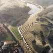
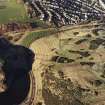
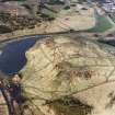
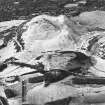
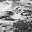
An extensive area of rig-and-furrow cultivation can be seen on the lower slopes of Whinny Hill and is cut by the Queen's Drive. The rigs are best preserved on the S, where they extend for a maximum distance of 190m, curving S at their western ends and measuring from 7m to 8m in breadth and up to 0.3m in height. A linear feature has been cut roughly from N to S across the cultivation on the E side of the Queen's Drive, but its date and purpose are unknown. A small ring-ditch (NT27SE 3976), located immediately within the Park wall, also overlies the rigs. The rig-and-furrow and the ring-ditch are plotted at 1:5,550 on an archaeological map of Holyrood Park (RCAHMS 1999).
Visited by RCAHMS (ARG), 15 December 1998.
NMRS, MS/726/96 (60-1, no. 51); RCAHMS 1999.

