Accessibility

Font Size

100% 150% 200%

Background Colour

Default Contrast
Close Reset

Pitmackie

Farmstead (Period Unassigned)

Site Name Pitmackie

Classification Farmstead (Period Unassigned)

Canmore ID 156906

Site Number NN84SW 23

NGR NN 8170 4046

Datum OSGB36 - NGR

Permalink http://canmore.org.uk/site/156906

Ordnance Survey licence number AC0000807262. All rights reserved.
Canmore Disclaimer. © Bluesky International Limited 2025. Public Sector Viewing Terms

Toggle Aerial | View on large map

Digital Images

Walkover survey photographs, Pitmackie Hydro-Electric Scheme Glen Quoich, Perthshire
Walkover survey photographs, Pitmackie Hydro-Electric Scheme Glen Quoich, PerthshireGlen Quaich, oblique aerial view, taken from the SSE, general view.Pitmackie and Leachan, oblique aerial view, taken from the SE, centred on the footings of a farmstead. The remains of two further farmsteads are visible in the bottom half of the photograph.Pitmackie and Leachan, oblique aerial view, taken from the ESE, centred on the footings of two farmsteads. The remains of a further farmstead is visible in the top half of the photograph.Oblique aerial view of the farmsteads at Pitmackie, looking S.Walkover survey, Site 2, Building 1, viewed from the W, Pitmackie Hydro-Electric Scheme, Glen Quoich, PerthshireOblique aerial view of the farmsteads at Pitmackie, looking S.Pitmackie and Leachan, oblique aerial view, taken from the SSE, showing the remains of five farmsteads across the photograph.Pitmackie and Leachan, oblique aerial view, taken from the SE, centred on the footings of a farmstead. The remains of two further farmsteads are visible in the bottom half of the photograph.Glen Quaich, oblique aerial view, taken from the SE, general view.Walkover survey, Site 2, Building 2, viewed from the N, Pitmackie Hydro-Electric Scheme, Glen Quoich, Perthshire

Administrative Areas

  • Council Perth And Kinross
  • Parish Dull
  • Former Region Tayside
  • Former District Perth And Kinross
  • Former County Perthshire

Archaeology Notes

NN84SW 23 8170 4046.

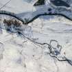
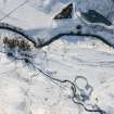
Aerial photography (RCAHMSAP 1996) has recorded the remains of a farmstead consisting of three buildings on either side of a trackway 65m E of Pitmackie farmsteading. It is not depicted on the 1st edition of the OS 6-inch map (Perthshire 1867, sheet lx and Perthshire 1867, sheet lix) or the current edition of the 1:10000 map sheet (1976).

Information from RCAHMS (KB) 7 February 2000

Activities

Field Visit (24 May 2013)

NN 8056 4008 – NN 8190 4033, NN 8122 4100 – NN 8149 4049 Walkover surveys were undertaken on 24 May 2013 along the proposed routes of two hydro-electric schemes at Pitmackie, Glen Quaich. A desk-based assessment had identified the remains of several farmsteads (NN84SW 11, NN84SW 12, NN84SW 13, NN84SW 14, NN84SW 23, NN84SW 24) along these routes. However, two further settlements were encountered during the walkover survey. The scant remains of a probable farmstead consisting of two, or possibly three, buildings was identified on the N bank of the River Quaich at NN 81615 40334. Close to an unnamed burn that feeds into the river, at NN 81229 40864, stand the surviving courses of what was probably a shieling hut.

Archive and report: PKHT and RCAHMS

Funder: Green Highland Renewables

John Lewis, Scotia Archaeology, 2013

(Source: DES)

References

MyCanmore Image Contributions


Contribute an Image

MyCanmore Text Contributions