
Gaich Wood


Cairn (Bronze Age)
Site Name Gaich Wood
Classification Cairn (Bronze Age)
Canmore ID 15685
Site Number NJ02NW 1
NGR NJ 0118 2561
Datum OSGB36 - NGR
Permalink http://canmore.org.uk/site/15685


- Council Highland
- Parish Cromdale, Inverallan And Advie
- Former Region Highland
- Former District Badenoch And Strathspey
- Former County Morayshire
NJ02NW 1 NJ 0118 2561.
(NJ 0118 2561) Cairn (NR)
OS 6" map, Morayshire, 1st ed., (1874)
No trace of this cairn. The area is closely afforested. (No information in the relevant Name Book)
Visited by OS (D A) 31 October 1955.
No trace of this cairn; presumably destroyed by afforestation.
Visited by OS (N K B) 1 September 1966.
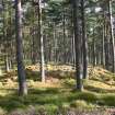
This cairn has not been destroyed by the planting of trees as previously reported, but survives in a mature plantation 250m SW of Upper Gaigh farmsteading. Situated on a gentle SE-facing slope, the cairn measures 19m from NW to SE by 14m transversely over a mound of rubble up to 1m in height on the NE. Several hollows in the surface of the mound appear to be the result of robbing, some of it comparatively recent.
Visited by RCAHMS (AGCH) 11 October 2006.
Field Visit (24 September 1943)
This site was included within the RCAHMS Emergency Survey (1942-3), an unpublished rescue project. Site descriptions, organised by county, vary from short notes to lengthy and full descriptions and are available to view online with contemporary sketches and photographs. The original typescripts, manuscripts, notebooks and photographs can also be consulted in the RCAHMS Search Room.
Information from RCAHMS (GFG) 10 December 2014.
Project (March 2007)
Detailed measured survey was undertaken in the Braes of Abernethy, Highland, by RCAHMS over the course of one week in March 2007. The archaeological and architectural monuments recorded were identified as worthy of further attention during a survey undertaken in 2006 (see Project Event 555817). The survey was designed to record a representative sample of the sites recorded in 2006, particularly those that were otherwise under-represented in then National Monuments Record of Scotland (now the National Record of the Historic Environment (NRHE)). The Pictish barrow cemetery at Pityoulish is situated outside the area of the original survey, but the opportunity to record it in detail for the first time was thought to be too good a chance to miss. Accordingly two parts of the site were recorded – the group of four ditched mounds at the NE end (Canmore ID 15389) and a solitary kerbed cairn 230m to the SW (Canmore ID 15413).
Information from HES Survey and Recording (JRS) 18 April 2018.

