
Pricing Change
New pricing for orders of material from this site will come into place shortly. Charges for supply of digital images, digitisation on demand, prints and licensing will be altered.
Castlehaven


Promontory Fort (Iron Age)
Site Name Castlehaven
Classification Promontory Fort (Iron Age)
Alternative Name(s) Earthwork
Canmore ID 15627
Site Number NH98NW 5
NGR NH 9296 8729
Datum OSGB36 - NGR
Permalink http://canmore.org.uk/site/15627


- Council Highland
- Parish Tarbat
- Former Region Highland
- Former District Ross And Cromarty
- Former County Ross And Cromarty
NH98NW 5 9296 8729.
(NH 9296 8729) Castlehaven (NR) (Site of)
OS 6" map, (1959)
"There is a tradition of a fort, built here on a small mote . . . No vestiges remain of the building, both the mote and a narrow neck or causeway which led to it from the land being now covered with grass; but it is easy to trace the foundation of a wall of considerable extent, which defended it on the land side. The creek retains the name of Port-Chasteil or Castlehaven."
Statistical Account (OSA) 1793.
The site of an ancient castle or fort defended on the land side by a deep ditch, and by some supposed to be the ancient 'Ethirdover'.
Orig Paroch Scot 1855.
The site of an ancient castle of which no vestige remains other than parts of two ditches which appear to have formed the defence on the landward side.
Name Book 1872.
Only two dressed sandstone blocks, presumably part of a wall-face, remain, protruding through the SSE arc of an amorphous turf-covered mound of debris.
Both ditches can still be traced, the inner being partly filled with field cleared stones, and the outer ploughed down. Both ditches average 4m in width and 0.3m deep.
Revised at 1:2500.
Visited by OS (A A) 14 September 1972
This has been a desk assessment area.
J Wordsworth, SSSIs, Scottish Natural Heritage, 1993
Castlehaven is generally as described but the outer ditch is now very vague and masked by whins.
Surveyed at 1:10,000.
Visited by OS (J B) 21 September 1977.
Field Visit (November 1977)
Castlehaven NH 929 872 NH98NW 5
This promontory fort has been defended by a single rampart on the E and N; on the S, where the approach is easiest. Extra protection has been provided by the addition of three ditches. In the interior there is a D-shaped enclosure.
RCAHMS 1979, visited September 1977
(Stat Acct, vi 1793, 426-7; Name Book, Ross-shire, no. 30, p. 5)
Field Visit (26 February 2014)
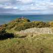
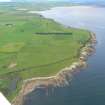
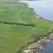
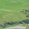
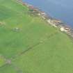
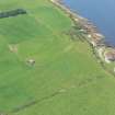
This fort is situated on a promontory which extends into the Dornoch Firth from the N coast of the Tarbat peninsula. Although there is easy access from both sea and land, the E and W sides of the promontory are steep, developing into sheer cliff in places, and it represents the most easily defended location on this stretch of coastline. The remains probably represent at least two phases of construction, the first of these comprising a pair of ramparts and ditches arcing across the landward end of the promontory and the second consisting of a building standing within a stone-walled enclosure within the earlier defences.
Of these early defences, the inner ditch is the best preserved feature, measuring up to 7.5m in breadth by 1.5m in depth, though much of its profile has been obscured by the dumping within it of stones cleared from the adjacent once arable ground. The wall or bank that accompanied the ditch along its inner edge has been robbed to such an extent that it is now only detectable as a vague stony sensation underfoot. The outer line of defence comprises the ploughed down remains of a low bank up to about 7m thick and a shallow ditch outside it up to 5.5m broad.
The building forms the most prominent feature of the site but there is nothing to suggest that its present mound-like appearance represents anything more than its collapsed remains. Visible external facing-stones on the S and NE, and probable inner facing-stones on the N indicate a structure measuring at least 16m from N to S by 7m transversely within a stone wall in the region of 2m thick. There has clearly been erosion to its W side but it is not possible to estimate with any accuracy how much of the structure has been lost.
It stood within the S end of a long narrow enclosure measuring 56.5m from N to S by at least 12.5m transversely within a wall up to 2m thick but now largely reduced to little more than footings. At its southern end the enclosure wall has been drawn across the neck of the promontory and it is possible that this phase of enclosure made use of the earlier inner ditch. The wall then ran down the E side of the promontory, its inner edge probably following the line of the natural crest (where there was a steep natural slope below) until it was forced to follow the cliff-edge as it descended towards the high water mark. At the lowest point on the promontory (at its N end) the wall swung round before following the eastern cliff-edge back up towards the summit, where its remains cannot now be discerned amidst the rubble representing the collapsed fabric of the building. A short stretch of inner face is visible immediately SE of the building, where there is 4.5m gap between the two, and fragments of a battered outer face are visible immediately E.
At a point on the E side where it is possible that the enclosure wall was once broken by a gap which allowed access to the beach via a path, there is a small oval hut. It measures about 4.5m from NE to SW by 3.5m transversely within a stone wall about 1m in thickness. Two possible inner facing-stones are visible on the W and the interior on the S seems to have been dug into the natural slope. No other obvious structures are present, but the area of the interior has been disturbed by quarrying, both of the remains of the building and the enclosure wall, and probably also the natural bedrock. A track which may have provided access to the quarries is depicted on the 1st edition of the OS 25-inch map (Ross-shire Sheet XXX.6, 1880), a map which also provides a good representation of the earliest identifiable period of prehistoric defence.
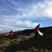
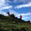
Visited by RCAHMS (GFG, JRS, IP), 26 February 2014.
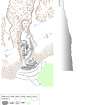
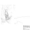
Measured Survey (25 February 2014)
RCAHMS surveyed Castlehaven promontory fort with plane-table and self-reducing alidade on 25 February 2014 at a scale of 1:500. Control points and sections were recorded with dGPS. The resultant plan and sections were redrawn in vector graphics software.
Note (25 March 2015 - 31 May 2016)
The remains of this fortification are situated on a rocky promontory on the N coast of the Tarbat peninsular. In general the surface of the promontory planes down towards the sea on the N, but the sides are steep and in places develop into low cliffs, particularly along its W margin. The defences comprise two elements: a pair of outer ramparts with external ditches across the neck of the promontory barring access from the S; and an inner enclosure around a substantial structure embedded in a large mound of rubble. Roughly D-shaped on plan, with a few outer facing-stones visible on the S and NE, and possible inner facing-stones on the N, the structure in this mound probably measures about 16m from N to S by at least 7m transversely within a wall in the order of 2m in thickness. This appears to have stood within the S end of a larger enclosure measuring about 56m from N to S by 12m transversely (0.05ha) within a wall reduced to little more than a band of rubble, which swings concentrically across the neck on the S to follow the E margin of the promontory down to the edge of the sea on the N and return along the W until it disappears in the rubble of the mound. The inner rampart of the outer defences drawn across the neck of the promontory on the S has been heavily robbed but was evidently of some size, fronted by a ditch that measures 7.5m in breadth by up to 1.5m in depth where it is not filled with field-cleared stones. The outer rampart and ditch have been equally heavily reduced, but appear to follow a slightly eccentric line diverging towards the W. The relationships between these various defences are unknown, but a trackway that can be seen cutting across the outer lines on the E is more likely to relate to robbing and stone quarrying in the interior than access to the inner enclosure. The only other feature visible within the interior is an oval hut overlying the wall of the inner enclosure on the E.
Information from An Atlas of Hillforts of Great Britain and Ireland – 31 May 2016. Atlas of Hillforts SC2919

