
Pricing Change
New pricing for orders of material from this site will come into place shortly. Charges for supply of digital images, digitisation on demand, prints and licensing will be altered.
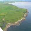
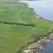
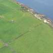
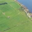
Blar A' Chath


Cairn(S) (Period Unassigned)
Site Name Blar A' Chath
Classification Cairn(S) (Period Unassigned)
Canmore ID 15626
Site Number NH98NW 4
NGR NH 927 870
Datum OSGB36 - NGR
Permalink http://canmore.org.uk/site/15626


- Council Highland
- Parish Tarbat
- Former Region Highland
- Former District Ross And Cromarty
- Former County Ross And Cromarty
NH98NW 4 927 870.
(Group: NH 927 870) Tumuli (NR) (Site of)
OS 6" map, Ross-shire, 2nd ed., (1907)
A number of small irregular mounds, supposed to be the burial places of the victims of a battle that took place on Blar a' Chath. Some of the tumuli were destroyed in land reclamation.
Name Book 1872
No trace. 1st edition 25" shows more cairns than indicated here. Tumuli average 0.6m high by 2.0m in diameter (Information from OS revisor) Visited by OS (A A) 12 September 1972.
No change to previous field report.
Visited by OS (J B) 21 September 1977.

