
Scheduled Maintenance
Please be advised that this website will undergo scheduled maintenance on the following dates: •
Tuesday 3rd December 11:00-15:00
During these times, some services may be temporarily unavailable. We apologise for any inconvenience this may cause.
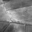
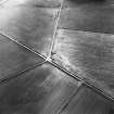
Moyness


Ring Cairn (Neolithic) - (Bronze Age), Stone Circle (Neolithic) - (Bronze Age)
Site Name Moyness
Classification Ring Cairn (Neolithic) - (Bronze Age), Stone Circle (Neolithic) - (Bronze Age)
Alternative Name(s) 'Mains Of Moyness'
Canmore ID 15582
Site Number NH95SE 7
NGR NH 9527 5366
Datum OSGB36 - NGR
Permalink http://canmore.org.uk/site/15582


- Council Highland
- Parish Auldearn
- Former Region Highland
- Former District Nairn
- Former County Nairn
NH95SE 7 9527 5366.
(NH 9527 5366) Stone Circles (NR) (Remains of).
OS 6" map (1906)
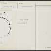
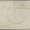
The remains of this ring-cairn are heavily overgrown with gorse. The remains consist of part of the outer kerb of the cairn, the NE part of which was destroyed by a road. The kerb is composed of irregular boulders up to 2 feet 9 inches in height. The cairn-material has been almost completely removed.
Of the outer circle, a single monolith, 4ft 6ins tall, remains, on the SE. Near it are several long thin slabs of stone, probably from the destruction of another monolith, while, on the NW of the cairn, there lies a large slab, probably another monolith, beside its original position. A row of boulders, the foundations of a field-wall, runs from this slab to the west side of the kerb.
The innermost circle, now gone, had a diameter of 24ft and was paved with small stones. The central area was excavated and an urn found in 1856.
A S Henshall 1963, visited 12 April 1957
The remains of the ring-cairn are as planned and described by Henshall.
Resurveyed at 1/2500.
An additional stone has been supplied on the plan supplied from Henshall.
Visited by OS (RD) 26 August 1965.
Field Visit (21 September 1943)
This site was included within the RCAHMS Emergency Survey (1942-3), an unpublished rescue project. Site descriptions, organised by county, vary from short notes to lengthy and full descriptions and are available to view online with contemporary sketches and photographs. The original typescripts, manuscripts, notebooks and photographs can also be consulted in the RCAHMS Search Room.
Information from RCAHMS (GFG) 10 December 2014.
Field Visit (May 1978)
Moyness (NRN 6) NH 952 536 NH95SE 7
The remains of this ring-cairn are visible in dense vegetation. A kerb of boulders standing up to 0.85m high surrounds the cairn and a single monolith stands to the SE.
RCAHMS 1978, visited May 1978
Henshall 1963-72, i, 388

