|
Manuscripts |
MS 974/7 |
|
Account of the destruction of the Moyness cairn from Forres, Elgin and Nairn Gazette, 9 March 1856. |
9/3/1856 |
Item Level |
|
|
Manuscripts |
MS 974/8 |
|
Account of the reaction to the story of the destruction of the Moyness cairn from Forres, Elgin and Nairn Gazette, 23 March 1856. |
23/3/1856 |
Item Level |
|
|
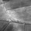
Photographs and Off-line Digital Images |
E 23741 |
RCAHMS Aerial Photography |
Oblique aerial view centred on the remains of the ring cairn, taken from the NE. |
12/2/2003 |
Item Level |
|
|
Photographs and Off-line Digital Images |
E 23742 |
RCAHMS Aerial Photography |
Oblique aerial view centred on the remains of the ring cairn, taken from the NNE. |
12/2/2003 |
Item Level |
|
 |
Digital Files (Non-image) |
WP 002403 |
Records of the Royal Commission on the Ancient and Historical Monuments of Scotland (RCAHMS), Edinbu |
Scanned copy of RCAHMS Emergency Survey: Manuscripts (1943 Volume 2). |
1943 |
Item Level |
|
 |
Digital Files (Non-image) |
WP 002412 |
Records of the Royal Commission on the Ancient and Historical Monuments of Scotland (RCAHMS), Edinbu |
RCAHMS Emergency Survey: Typescripts (Nairn). |
1943 |
Item Level |
|
|
Manuscripts |
MS 36/275 |
Records of the Royal Commission on the Ancient and Historical Monuments of Scotland (RCAHMS), Edinbu |
RCAHMS Emergency Survey; manuscripts 1943 (vol.2) |
1943 |
Item Level |
|
 |
On-line Digital Images |
SC 1696784 |
RCAHMS Aerial Photography |
Oblique aerial view centred on the remains of the ring cairn, taken from the NE. |
12/2/2003 |
Item Level |
|
 |
On-line Digital Images |
SC 1696785 |
RCAHMS Aerial Photography |
Oblique aerial view centred on the remains of the ring cairn, taken from the NNE. |
12/2/2003 |
Item Level |
|
 |
Digital Files (Non-image) |
WP 007514 |
Publications by the Royal Commission on the Ancient and Historical Monuments of Scotland |
(5) The Archaeological Sites and Monuments of Nairn District |
9/1978 |
Item Level |
|
 |
On-line Digital Images |
SC 2368509 |
Records of the Ordnance Survey, Southampton, Hampshire, England |
Moyness, NH95SE 7, Ordnance Survey index card, Recto |
1958 |
Item Level |
|
 |
On-line Digital Images |
SC 2368510 |
Records of the Ordnance Survey, Southampton, Hampshire, England |
Moyness, NH95SE 7, Ordnance Survey index card, page number 1, Recto |
1958 |
Item Level |
|
 |
On-line Digital Images |
SC 2368511 |
Records of the Ordnance Survey, Southampton, Hampshire, England |
Moyness, NH95SE 7, Ordnance Survey index card, page number 2, Verso |
1958 |
Item Level |
|
 |
On-line Digital Images |
SC 2368512 |
Records of the Ordnance Survey, Southampton, Hampshire, England |
Moyness, NH95SE 7, Ordnance Survey index card, Recto |
1958 |
Item Level |
|
 |
On-line Digital Images |
SC 2368513 |
Records of the Ordnance Survey, Southampton, Hampshire, England |
Moyness, NH95SE 7, Ordnance Survey index card, page number 1, Recto |
1958 |
Item Level |
|
 |
On-line Digital Images |
SC 2368514 |
Records of the Ordnance Survey, Southampton, Hampshire, England |
Moyness, NH95SE 7, Ordnance Survey index card, Recto |
1958 |
Item Level |
|
|
All Other |
551 166/1/1 |
Records of the Ordnance Survey, Southampton, Hampshire, England |
Archaeological site card index ('495' cards) |
1947 |
Sub-Group Level |
|


