
Avielochan


Fort (Prehistoric)
Site Name Avielochan
Classification Fort (Prehistoric)
Alternative Name(s) Laggantygown, Tor Beag
Canmore ID 15387
Site Number NH91NW 13
NGR NH 90518 17230
Datum OSGB36 - NGR
Permalink http://canmore.org.uk/site/15387


- Council Highland
- Parish Duthil And Rothiemurchus
- Former Region Highland
- Former District Badenoch And Strathspey
- Former County Inverness-shire
NH91NW 13 9052 1721.
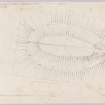
(Area NH 905 171) On Tor Beag, a rocky promontory, is a once strong stone-walled fort measuring internally about 220' by 80' within a ruinous wall enclosing the summit. Some 20' below summit level is a second line of defence mostly represented by a terrace. At the approach to the fort, along a narrow neck, is an outer wall of massive boulders (Feachem 1963).
Many flint arrowheads have been found in the neighbourhood (Grant 1885).
A Grant 1885; C G Cash 1910; R W Feachem 1963.
At NH 9052 1721, are the overgrown remains of a fort, the situation and dimensions of which are as described by Feachem. All that remains of the inner wall is a short tumbled stretch on either side of the entrance, showing one or two outer facing stones but insufficient remains to determine the wall thickness. The terrace forming the second line of defence, is visible for most of its periphery, save on the SE where it is obliterated by soil creep. On both sides of the entrance it is strengthened by a boulder faced wall spread to c. 3.5m. Outside this, to the S of the entrance, is a breastwork of similar construction, whilst on the other side of the entrance a ruined wall extends for a distance of c. 14.0m along the approach. The interior is featureless.
No further information regarding flint arrowheads.
Visited by OS (R L) 23 September 1969.
Field Visit (1 July 1958)
Fort, Avielochan
This fort is situated on a rocky promontory called Tor Beag which protrudes from the E flank of Beinn Ghuilbin at a point 560 yards N of Avielochan house an 270 yards W of the ruins of Laggantygown. It stands at an elevation of 950 feet OD, 250 feet above the River Spey where this runs between Beinn Ghuilbin and Pityoulish Hill and thus commands a section of Strathspey at the lowest point where this narrows to any marked extent as it runs NE between the high and inhospitable massifs of the Monadhliath to the W and the Cairngorms to the E. The fort, which occupies the hole of the promontory, is oval on plan measuring 220 feet in length from NE to SW by 80 feet transversely within the remains of a stone wall. Where this runs round the rim of the summit of the promontory it is represented by only a very slight tumble of stones, but the volume of debris is greater on either side of the entrance, in the SW. Immediately NW of this there is a stretch 18 feet in length in which the outer face of the wall is preserved up top three courses in height. As the ground slopes down from the entrance towards the neck of the promontory the remains of a second wall occur. A scatter of stones originates at a point on the steep W flank of the promontory distant 40 feet N of the entrance in the innermost wall. It runs S along the gradually decreasing gradient for a distance of 70 feet before terminating at the entrance gap which lies 45 feet SW of that in the innermost wall. It resumes on the other side of this to run E for about 50 feet before dying out on the steep S flank of the promontory. A third wall, forming the second main line of defence, runs right round the promontory at a lower level. It appears as a considerable line of tumbled blocks and stones which forms the crest of a terrace some 10 feet in width. In the vicinity of the entrance, in the SW, several stones can be seen which probably formed part of the outer face, but no undoubted inner facing stones could be detected. Nevertheless, the appearance of the tumbled stones suggests that this wall may well have originally measured about 8 feet in thickness. Individual stones are very large. The entrance in this wall lies 60 feet SW and 25 feet below that of the central enclosure. Two other minor walls were noted. One, forming an arc about 60 feet in length, runs SE from a point just outside the entrance in the outer wall for 30 feet, whereupon it gains the crest where the SE flank of the promontory increases in steepness. It immediately curves NE to die out on the hillside after a further 30 feet. This wall is quite well preserved and a stretch 30 feet of the outer face is visible along the SW arc. The second outside wall is very much less east to follow and it has only been shown as a line of dashes on the plan. It appears to run SW from the NW side of the entrance in the outer wall in an almost straight line, to border the narrow col joining the promontory to the adjacent land. The steepness of the slope, however, and possibly the action of stone robbers has made it impossible to trace its course or length with certainty.
The whole of the site, up to the wire fence that runs athwart the col, was covered with a dense growth of conifers and junipers on the date of visit, and nothing could be seen of the surface of the interior. A stone quarry was being worked in the E flank of the promontory.
905 171
OS map lviii (Unoted)
Visited by RCAHMS (RWF) 1 July 1958
Reference (1963)
This site is noted in the ‘List of monuments discovered during the survey of marginal land (1956-8)’, published in Vol. 1 of the RCAHMS Inventory of Stirlingshire. The 26 monuments were listed by their name, classification, parish and county, and the list also includes an indication of whether they had been planned (P), whether they were visible only as a cropmark (C), and whether they were worthy of preservation (*).
Information from RCAHMS (GFG) 30 October 2012.
Note (24 March 2015 - 31 August 2016)
This fort occupies a rocky hillock that forms a promontory projecting NE from the foot of the SE flank of Beinn Ghuilbin. Oval on plan, it measures about 66m from NNE to SSW by 23m transversely (0.12ha) within a wall reduced to little more than a stony scarp where it skirts the summit, and increasing in thickness to either side of the entrance on the SSW; the outer face is visible to the NW of the entrance. Traces of a second wall can be seen on the slope below the entrance above the gap in a third wall that forms an almost complete outer circuit on the leading edge of a lower terrace 3m wide about 15m beyond the inner wall enclosing the summit. It encloses an area measuring 95m from NNE to SSW by 55m transversely (0.41ha) and is again most substantial to either side of the entrance on the SSW, where the line of the outer face can also be traced to either side. The entrance opens onto the narrow col linking the hillock to the flank of the hill and is apparently protected by additional outwork, while between the inner and outer defences at this end there is a funnel-shaped arrangement of walls reduced to stony banks. The relationships between these various walls are unknown.
Information from An Atlas of Hillforts of Great Britain and Ireland – 31 August 2016. Atlas of Hillforts SC2913
Watching Brief (13 February 2017 - 18 April 2017)
NH 85339 09072 – NH 82924 26133 A watching brief was carried out, 13 February – 18 April 2017, during phase 2 of ground investigation work for the A9 project. A total of 83 trial pits, 7 soak-away pits and 6 borehole location spots were monitored on a 25km long corridor running beside the existing A9. The section stretched 4km SW to 13.5km NW of Aviemore.
No significant archaeological features or finds were recorded during the excavation work. However, three areas may have possible unrecorded archaeological features. Area 2, which contained the remains of two stone features and a possible post-medieval corn drying kiln; Area 10, which contained the remains of a dry stone wall and possible enclosure; and Area 18, which contained a rectangular earthwork that may relate to the nearby military road. None of these was impacted upon during the present work programme.
Archive: NRHE (intended)
Funder: Raeburn Drilling and Geotechnical Ltd on behalf of AMJV Atkins Mouchel Joint Venture and Transport Scotland
Maureen C Kilpatrick – GUARD Archaeology Ltd
(Source: DES, Volume 18)

