Loch Vaa
Crannog (Period Unassigned)
Site Name Loch Vaa
Classification Crannog (Period Unassigned)
Canmore ID 15385
Site Number NH91NW 11
NGR NH 9121 1745
Datum OSGB36 - NGR
Permalink http://canmore.org.uk/site/15385
- Council Highland
- Parish Duthil And Rothiemurchus
- Former Region Highland
- Former District Badenoch And Strathspey
- Former County Inverness-shire
NH91NW 11 9121 1745.
(Area NH 914 175) An island in Loch Vaa is said to be artificial. 'Wooden beams have been looked for and seen round the edge of the stone of which the island is composed'. It only shows above water in very dry weather.
F O Blundell 1913.
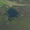
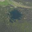
At NH 9129 1745 are the remains of a crannog visible as a pile of stones just protruding above the surface of the loch, which was at a very low level at the time of investigation. It measures approximately 15.0m in diameter overall and on the N and W resting on the submerged stones, are two logs, 1.0 to 1.5m long, which may be displaced piles.
Visited by OS (R L) 22 September 1969.
Archaeological Evaluation (May 2019)
NH 91300 17455 Survey and test pitting took place in May 2019 to assess the impact of low water level in Loch Vaa on the crannog site known in the loch (Canmore ID: 15385). In late 2018 and early 2019 the lowest water levels in recent memory led to the Loch Vaa crannog being exposed above the surface of the loch. The survey and test pitting aimed to assess the impact low water may have been having on surviving organic material within and on the crannog and to take samples for radiocarbon dating. No previous investigation of this site has been carried out other than to note its presence. Survey of the crannog mound both above and below water demonstrated that no timber or organic material was exposed above the surface of the loch during the period of low water level. Underwater, 18 individual timber structural elements were identified on or protruding out of the crannog mound. No vertical piling was identified, all timbers identified were horizontal. The survey and two small test pits (Trench 1, 1 x 1m; Trench 2, 0.5 x 0.5m) revealed organic deposits and structural timbers at least 0.15–0.20m below the water level as it was on 16 May 2019. In Trench 1, two parallel (running N-S) horizontal timbers were found. Both were undressed round logs preserved to bark edge. A sample was taken from the outermost 10 rings of one of these timbers, and it yielded a radiocarbon result of 849±26 (SUERC-87806) or cal AD 1055–1260 (95.4% probability).
Archive: Highland HER
Funder: Leverhulme Trust
Michael J Stratigos - Scottish Universities Environmental Research Centre
(Source: DES Vol 20)


