
Culmaily


Field System (Period Unassigned), Hut Circle (Prehistoric)
Site Name Culmaily
Classification Field System (Period Unassigned), Hut Circle (Prehistoric)
Canmore ID 15350
Site Number NH89NW 3
NGR NH 8037 9982
NGR Description NH 8037 9982 and NH 803 998
Datum OSGB36 - NGR
Permalink http://canmore.org.uk/site/15350


- Council Highland
- Parish Golspie
- Former Region Highland
- Former District Sutherland
- Former County Sutherland
NH89NW 3 8037 9982 and 803 998.
(NH 8037 9982) Hut Circle (NR)
(Centred NH 803 998) Cairns (NR)
OS 6" map, (1959)
A hut circle, with small mounds adjacent and a short distance to the NW.
RCAHMS 1911, visited 1909.
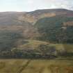
Built up on a S-facing hillside is a stone-walled hut, within an associated field system. It measures 9.2m in diameter within a wall, faced internally with contiguous stones set on edge visible around most of the wall thickness of 1.6m. The entrance, which is in the S, is flanked on its W side by a stone set on edge.
The field system is defined by stone clearance heaps (the "mounds" noted by the RCAHMS) with no field walls ar lynchets evident, but a succession of natural terraces appear to have been utilised to form fields, 20.0m x 15.0m average size.
Resurveyed at 1:2500.
Visited by OS (N K B) 7 February 1966 and 26 November 1969.

