
Wemyss Cemetery


Cemetery (19th Century)
Site Name Wemyss Cemetery
Classification Cemetery (19th Century)
Canmore ID 153345
Site Number NT39NW 236
NGR NT 3420 9705
Datum OSGB36 - NGR
Permalink http://canmore.org.uk/site/153345


- Council Fife
- Parish Wemyss
- Former Region Fife
- Former District Kirkcaldy
- Former County Fife
Earth Resistance Survey (14 July 2019)
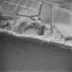
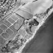
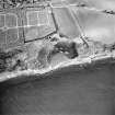
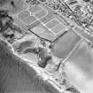
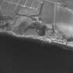
NT 34339 97152 Members of the Edinburgh Archaeological Field Society (EAFS) carried out resistivity survey of an 80m x 40m area along the south eastern edge of Wemyss and Macduff cemetery. Two tentative anomalies were detected. In the westernmost grid of the survey area was a circular area of very low resistance, approximately 4m in diameter. Extending across the two south easternmost grids, adjacent to Macduff’s Castle was a curvilinear feature of higher resistance which appears to cut across the more amorphous area of very low resistance.
Information from J. Hambly - SCAPE Trust.
OASIS ID: thescape1-504522
Note (1 May 2024)
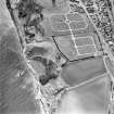
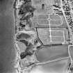
A cemetery is depicted on the 2nd edition of the OS 6-inch map (1896). An enlarged cemetery is visible on the 3rd edition of the OS 6-inch map (1920). A further enlarged cemetery digitised from orthoimagery provided by Getmapping PLC. Core ID: 4960601. OS 1km map square NT3497 flown on 29 June 2023.
Information from HES (D Watson) 1 May 2024

