
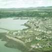
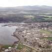
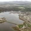
Lewis, Stornoway, Power Station


Power Station (20th Century)
Site Name Lewis, Stornoway, Power Station
Classification Power Station (20th Century)
Alternative Name(s) Battery Point
Canmore ID 153197
Site Number NB43SW 39
NGR NB 43149 32180
NGR Description Centred NB 43149 32180
Datum OSGB36 - NGR
Permalink http://canmore.org.uk/site/153197


- Council Western Isles
- Parish Stornoway
- Former Region Western Isles Islands Area
- Former District Western Isles
- Former County Ross And Cromarty
NB43SW 39 centred 43149 32180
Power Station [NAT]
OS MasterMap (GIS), October 2008.
Location formerly entered as NB 4317 3218.

