 |
On-line Digital Images |
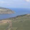
DP 341244 |
Papers of James Sloan Bone, landscape historian, Inverness, Highland, Scotland |
Aerial view of South Sutor, The Cromarty Firth and North Sutor, looking NE. |
16/3/2008 |
Item Level |
|
 |
On-line Digital Images |
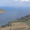
DP 341245 |
Papers of James Sloan Bone, landscape historian, Inverness, Highland, Scotland |
Aerial view of South Sutor, The Cromarty Firth and North Sutor, looking NE. |
16/3/2008 |
Item Level |
|
 |
On-line Digital Images |
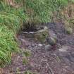
DP 365252 |
Historic Environment Scotland |
The well on the S side of the footpath from the NE |
21/2/2020 |
Item Level |
|
 |
On-line Digital Images |
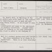
SC 2367789 |
Records of the Ordnance Survey, Southampton, Hampshire, England |
St Mary's Well, NH86NW 4, Ordnance Survey index card, Recto |
c. 1958 |
Item Level |
|
 |
On-line Digital Images |
SC 2367790 |
Records of the Ordnance Survey, Southampton, Hampshire, England |
St Mary's Well, NH86NW 4, Ordnance Survey index card, Recto |
c. 1958 |
Item Level |
|
 |
On-line Digital Images |
SC 2367791 |
Records of the Ordnance Survey, Southampton, Hampshire, England |
St Mary's Well, NH86NW 4, Ordnance Survey index card, page number 2, Verso |
c. 1958 |
Item Level |
|
|
All Other |
551 166/1/1 |
Records of the Ordnance Survey, Southampton, Hampshire, England |
Archaeological site card index ('495' cards) |
1947 |
Sub-Group Level |
|


