
St Mary's Well


Well (Period Unassigned)
Site Name St Mary's Well
Classification Well (Period Unassigned)
Alternative Name(s) Sutor Of Cromarty; South Sutor
Canmore ID 15238
Site Number NH86NW 4
NGR NH 8050 6723
Datum OSGB36 - NGR
Permalink http://canmore.org.uk/site/15238


- Council Highland
- Parish Cromarty
- Former Region Highland
- Former District Ross And Cromarty
- Former County Ross And Cromarty
NH86NW 4 8050 6723
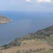
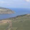
St. Mary's Well, on the slope of the Sutor, beside the middle path which leads to 'The Lookout' (NH 8118 6690) is traditionally said to mark the spot where a Trinitarian Friary stood. It is alleged to have been founded in 1271.
Easson (1957) has investigated and comes to the conclusion that the Friary is probably fictitious. Alleged references to the friars of Cromarty in the Lord Treasurer's Accounts have been found to refer to the ferrymen of Cromarty.
D E Easson 1957; G Mackenzie 1958.
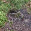
St. Mary's Well is a natural spring which was located at NH 8050 6723. The slope hereabouts is so steep as to render building impractical. There is no local knowledge of a friary in the area.
Visited by OS (N K B) 28 January 1966.
No change to previous field report.
Surveyed at 1:10 000.
Visited by OS (J B) 16 November 1978.
Field Visit (21 February 2020)
This well is situated immediately S of a footpath, where a natural spring emerges from the steep N-facing slope. The water seeps into a crude hemispherical basin measuring 1.03m from N to S by 0.89m transversely, retained on its downhill side by an arc of stone parapet 0.17m in thickness and 0.67m in height. An overflow pipe in the N face of the parapet conveys the surplus water into a culvert running beneath the path onto the slope below.
Visited by HES, Survey and Recording (ATW, AKK), 21 February 2020.

