
Glasgow, Kelvingrove Park, New Park Footbridge


Footbridge (20th Century)
Site Name Glasgow, Kelvingrove Park, New Park Footbridge
Classification Footbridge (20th Century)
Alternative Name(s) River Kelvin
Canmore ID 150941
Site Number NS56NE 1078
NGR NS 57053 66311
Datum OSGB36 - NGR
Permalink http://canmore.org.uk/site/150941


- Council Glasgow, City Of
- Parish Glasgow (City Of Glasgow)
- Former Region Strathclyde
- Former District City Of Glasgow
- Former County Lanarkshire
NS56NE 1078 57053 66311
For predecessor Old Park Footbridge (NS c. 5705 6631), see NS56NE 4880.
Foot Bridge [NAT]
OS 1:1250 map, 1972.
Footbridge in Kelvingrove Park, 1964. Engineer W T Docherty of Ronald Walker & Co. A single span of white reinforced concrete, the form derived from Rober Maillart's three-hinged designs in Switzerland in the interwar years, but the profile exceptionally low. The deck is is 3.6m (12ft), wide, with neat raisl of closely spaced steel uprights and a timber handrail.
E Williamson, A Riches and M Higgs1990.
New Park Footbridge: this bridge was designed by Ronald Walker and Co, and comprises a gently-arched concrete deck slab supported by a concrete frame on foundations buried just below the water line. The structure has a simple satisfying appearance, spoiled somewhat by the unsightly water marks on the frame legs.
D Boyce 1996.
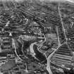
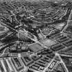
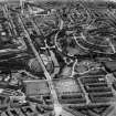
This bridge carries a footpath across the River Kelvin within the area of Kelvingrove Park (NS56NE 328); it remains in regular use. The river here forms the boundary between the parishes of Govan (to the W) and Glasgow (to the E).
The location cited is for the centre of the span, which appears to extend from NS c. 57044 66317 to NS c. 57075 66298.
Information from RCAHMS (RJCM), 5 December 2005.
Project (2007)
This project was undertaken to input site information listed in 'Civil engineering heritage: Scotland - Lowlands and Borders' by R Paxton and J Shipway, 2007.
Publication Account (2007)
An elegant structure with a span of 135 ft and width of 12 ft erected in 1964 from a design thought to be influenced by Swiss engineer Robert Maillart’s three-hinged concrete arches. The engineer was W. T. Doherty of Ronald Walker & Co.
R Paxton and J Shipway 2007
Reporduced from 'Civil Engineering heritage: Scotland - Lowlands and Borders' with kind permission of Thomas Telford Publishers.

