
Kirkcudbright Bridge


Road Bridge (Period Unassigned)
Site Name Kirkcudbright Bridge
Classification Road Bridge (Period Unassigned)
Alternative Name(s) River Dee; Kirkcudbright Harbour, Bridge; Kirkcudbright, Bridge Street, Bridge
Canmore ID 150219
Site Number NX65SE 115
NGR NX 68421 51257
Datum OSGB36 - NGR
Permalink http://canmore.org.uk/site/150219


- Council Dumfries And Galloway
- Parish Kirkcudbright
- Former Region Dumfries And Galloway
- Former District Stewartry
- Former County Kirkcudbrightshire
NX65SE 115 68421 51257
Kirkcudbright Bridge []NAT]
OS 1:10,000 map, 1990.
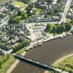
(Location cited as NX 684 513). Bridge, built 1924. 5-span, reinforced concrete, bowed-truss bridge.
J R Hume 1976.
Bridge, Bridge Street. By Blyth & Blyth and L G Mouchel & Partners, 1924-6. Five-span bow-truss concrete bridge with no pretension to prettiness.
J Gifford 1996.
Kirkcudbright Bridge carries the A755 public road (here forming a continuation of Bridge Street) across the River Dee to the NW of Kirkcudbright (NX65SE 67) and to the NE of Kirkcudbright Harbour (NX65SE 11). The river here forms the boundary between the parishes of Kirkcudbright (to the SE) and Twynholm (to the NW).
Information from RCAHMS (RJCM), 14 March 2006.

