
Pricing Change
New pricing for orders of material from this site will come into place shortly. Charges for supply of digital images, digitisation on demand, prints and licensing will be altered.
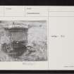
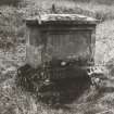
Dornoch, Station Road, St Michael's Well


Well (Period Unassigned)
Site Name Dornoch, Station Road, St Michael's Well
Classification Well (Period Unassigned)
Canmore ID 14853
Site Number NH79SE 8
NGR NH 79893 90003
Datum OSGB36 - NGR
Permalink http://canmore.org.uk/site/14853


- Council Highland
- Parish Dornoch
- Former Region Highland
- Former District Sutherland
- Former County Sutherland
NH79SE 8 79893 90003
(NH 7989 9001) St. Michael's Well (NR) (site of)
OS 6" map, (1960)
St. Michael's Well "This name applies to a very large spring of splendid water. Some 20 years ago it was partially covered in with stonework to protect it from Cattle etc. It is one of the points of the Parliamentary Boundary of the Burgh".
Name Book 1873.
On OS 25" map, 1905 an engine shed occupies the site. Only the foundations of the shed survive, and there is no trace of the well. The railway was built about 1902. About 6.0m E of the published site is a stone built obelisk inscribed "St. Michael's Well", which is undoubtedly commemorative as it is not part of a well. It may have been erected in 1868, as there is a local tradition that in that year a local MP moved St. Michael's Well "about 200 yards to the NE" presumably from its original site, though this sounds dubious.
Visited by OS (A A), 29 March 1971.

