
Pricing Change
New pricing for orders of material from this site will come into place shortly. Charges for supply of digital images, digitisation on demand, prints and licensing will be altered.
Drummond Park


Policies (Post Medieval)
Site Name Drummond Park
Classification Policies (Post Medieval)
Alternative Name(s) Drummond Policies
Canmore ID 148272
Site Number NN81NW 2.08
NGR NN 8499 1770
NGR Description Centred NN 8499 1770
Datum OSGB36 - NGR
Permalink http://canmore.org.uk/site/148272


- Council Perth And Kinross
- Parish Muthill
- Former Region Tayside
- Former District Perth And Kinross
- Former County Perthshire
Field Visit (4 September 1996)
NN 81 NW 2.08 8499 1770
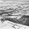
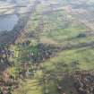
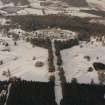
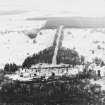
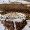
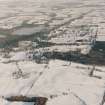
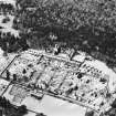
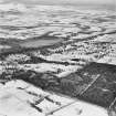
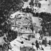
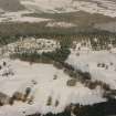
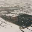
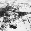
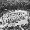
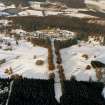
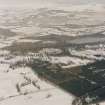
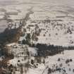
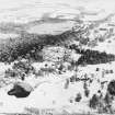
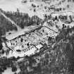
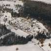
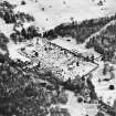
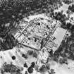
Drummond Park lies to the E and S of the Castle and to the W of the Crieff to Muthill Road. The parkland is extensively planted and the woodland is maintained, but elements of earlier features have survived.
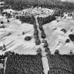
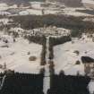
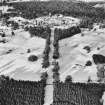
The tarmac drive approaching the castle from the E appears to have had at least one antecedent. A partly tree-lined drive departs from the line of the modern drive to the S of the Pond of Drummond (NN 8549 1813) and can be traced as far as the SE corner of the formal gardens (NN 8472 1793).A second grassed-over roadway can be traced from near the Crieff to Muthill road (NN 8576 1797) from where it runs along the N side of the Drummond Burn, crossing over to the S side of the burn (NN 8514 1795) and disappearing to the SSE of the formal gardens (NN 8468 1784).
At the N edge of the parkland a dried-out oval pond (NN 8488 1802), measuring 98m from E to W by 38m transversely, has been excavated out of a shallow gully, and an earth and stone dam has been constructed at the E end.
The parkland has been divided up by a series of shelter belts, all aligned approximately from NNW to SSE and enclosed by earth and stone banks. The lines of most of these plantations are depicted on the 1st edition of the OS 6-inch map (Perthshire 1866, sheet cvii) and many have been formalised in the field layout shown on the current edition of the OS 1:10000 map (1973). Circular and oval plantations, also enclosed by earthen banks, have been disposed across the parkland. A stone-built loading ramp (NN 8515 1748) has been built on top of one of the earthen banks of a shelter belt.
The core of the policies was already established by the mid-18th century. General Roy's map (1747-55) depicts the castle, the formal gardens to the S, several plantations, a broad avenue of trees to the S of the gardens, an avenue leading E from the Castle through a plantation to the Crieff road, and continuing beyond, and an area of farmland, both to the N and S of the castle, and to the W of the main road to Crieff, which is defined by a partly tree-lined boundary on the N, E and S. This latter area which does not display any internal features except rigged land, appears to mark the edge of the park shown on later maps (e.g. Knox's survey plan of 1810 and the 1st edition OS 6-inch map). The six farmsteads or townships S of the park shown by Roy lost a large part of their arable in this emparkment. Indeed of these, only Borland has survived the process of enclosure and emparkment. Comparison of Roy's military survey and the estate survey by James Knox in 1810 indicates that many of the shelter-belts and small plantations were established in the late 18th or early 19th century (Jamieson 1993). The late plan shows two lines of trees splaying out from the gardens to either side of the main avenue to the S of the castle. It also depicts the large pond that was raised over the late 18th century veteran's village (see NN81NE 75).
Visited by RCAHMS (DCC and PJD) 4 September 1996
W Roy 1757-55; F Jamieson 1993

