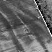
 |
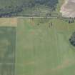
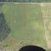
On-line Digital Images |
SC 342802 |
John Dewar |
Oblique aerial view of the cropmarks of the two souterrains. Cropped version of the original. |
1963 |
Item Level |
|
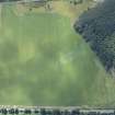 |
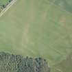
On-line Digital Images |
DP 160757 |
RCAHMS Aerial Photography Digital |
Oblique aerial view of the cropmarks of the old water courses and the enclosure, looking SSE. |
13/8/2013 |
Item Level |
|
 |
On-line Digital Images |
DP 160758 |
RCAHMS Aerial Photography Digital |
Oblique aerial view of the cropmarks of the old water courses and the enclosure, looking NE. |
13/8/2013 |
Item Level |
|
 |
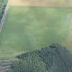
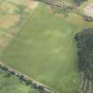
On-line Digital Images |
DP 163132 |
RCAHMS Aerial Photography Digital |
Oblique aerial view of the cropmarks of the enclosures and souterrains, looking NNW. |
19/7/2013 |
Item Level |
|
 |
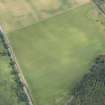
On-line Digital Images |
DP 163136 |
RCAHMS Aerial Photography Digital |
Oblique aerial view of the cropmarks of the enclosures, looking SSE. |
19/7/2013 |
Item Level |
|
 |
On-line Digital Images |
DP 163137 |
RCAHMS Aerial Photography Digital |
Oblique aerial view of the cropmarks of the enclosures and souterrains, looking NE. |
19/7/2013 |
Item Level |
|
 |
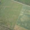
On-line Digital Images |
DP 163269 |
RCAHMS Aerial Photography Digital |
Oblique aerial view of the cropmarks of the structures, enclosures and rig, looking SE. |
31/7/2013 |
Item Level |
|
 |
On-line Digital Images |
DP 163270 |
RCAHMS Aerial Photography Digital |
Oblique aerial view of the cropmarks of the structures, enclosures and rig, looking E. |
31/7/2013 |
Item Level |
|
 |
On-line Digital Images |
DP 163273 |
RCAHMS Aerial Photography Digital |
Oblique aerial view of the cropmarks of the structures, enclosures and rig, looking NNW. |
31/7/2013 |
Item Level |
|
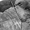 |
On-line Digital Images |
SC 1782897 |
RCAHMS Aerial Photography |
Oblique aerial view. |
1977 |
Item Level |
|
 |
On-line Digital Images |
SC 2366883 |
Records of the Ordnance Survey, Southampton, Hampshire, England |
Baddan, NH79NE 33, Ordnance Survey index card, Recto |
c. 1958 |
Item Level |
|
 |
On-line Digital Images |
SC 2366884 |
Records of the Ordnance Survey, Southampton, Hampshire, England |
Baddan, NH79NE 33, Ordnance Survey index card, Recto |
c. 1958 |
Item Level |
|
 |
On-line Digital Images |
SC 2366885 |
Records of the Ordnance Survey, Southampton, Hampshire, England |
Baddan, NH79NE 33, Ordnance Survey index card, Recto |
c. 1958 |
Item Level |
|


