Accessibility

Font Size

100% 150% 200%

Background Colour

Default Contrast
Close Reset

Baddan

Enclosure (Period Unassigned)

Site Name Baddan

Classification Enclosure (Period Unassigned)

Canmore ID 14775

Site Number NH79NE 33

NGR NH 7846 9821

Datum OSGB36 - NGR

Permalink http://canmore.org.uk/site/14775

Ordnance Survey licence number AC0000807262. All rights reserved.
Canmore Disclaimer. © Bluesky International Limited 2025. Public Sector Viewing Terms

Toggle Aerial | View on large map

Digital Images

Oblique aerial view of the cropmarks of the structures, enclosures and rig, looking SE.
Oblique aerial view of the cropmarks of the structures, enclosures and rig, looking SE.Oblique aerial view of the cropmarks of the structures, enclosures and rig, looking E.Oblique aerial view.Baddan, NH79NE 33, Ordnance Survey index card, RectoOblique aerial view of the cropmarks of the enclosures and souterrains, looking NNW.Oblique aerial view of the cropmarks of the enclosures, looking SSE.Baddan, NH79NE 33, Ordnance Survey index card, RectoBaddan, NH79NE 33, Ordnance Survey index card, RectoOblique aerial view of the cropmarks of the two souterrains. Cropped version of the original.Oblique aerial view of the cropmarks of the enclosures and souterrains, looking NE.Oblique aerial view of the cropmarks of the old water courses and the enclosure, looking SSE.Oblique aerial view of the cropmarks of the structures, enclosures and rig, looking NNW.Oblique aerial view of the cropmarks of the old water courses and the enclosure, looking NE.

Administrative Areas

  • Council Highland
  • Parish Golspie
  • Former Region Highland
  • Former District Sutherland
  • Former County Sutherland

Archaeology Notes

NH79NE 33 7846 9821.

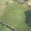
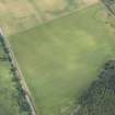
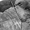
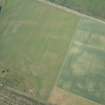
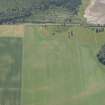
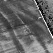
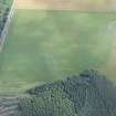
Cropmark traces of part of a small narrow-ditched enclosure with one narrow entrance and a large gap in the visible circumference may be seen on air photographs, some 370m SSW of the site described on NH79NE 32.

A F Harding and G E Lee 1987.

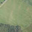
There is no trace of this enclosure, situated in a level hay field.

From the air photograph it measures about 12m across and appears to be sub-circular.

Visited by OS 28 May 1981.

References

MyCanmore Image Contributions


Contribute an Image

MyCanmore Text Contributions