
Pricing Change
New pricing for orders of material from this site will come into place shortly. Charges for supply of digital images, digitisation on demand, prints and licensing will be altered.
Baddan


Enclosure (Period Unassigned), Pit (Period Unassigned), Square Barrow (Iron Age)(Possible), Square Enclosure (Iron Age)
Site Name Baddan
Classification Enclosure (Period Unassigned), Pit (Period Unassigned), Square Barrow (Iron Age)(Possible), Square Enclosure (Iron Age)
Canmore ID 14773
Site Number NH79NE 31
NGR NH 7887 9854
Datum OSGB36 - NGR
Permalink http://canmore.org.uk/site/14773


- Council Highland
- Parish Golspie
- Former Region Highland
- Former District Sutherland
- Former County Sutherland
NH79NE 31 7887 9854.
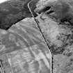
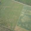
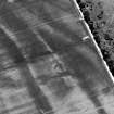
NH 788 985. Ring-ditch, Baddan.
Information from RCAHMS air photograph, 1977.
NH 7887 9854. There is no trace of the ring-ditch situated in a level hay field. From the air photograph it measures approximately 15.0m and appears to be near-circular.
Visited by OS (J B) 28 May 1981.

