
Dunragit


Field Boundary(S) (Post Medieval), Track (Post Medieval)
Site Name Dunragit
Classification Field Boundary(S) (Post Medieval), Track (Post Medieval)
Canmore ID 146155
Site Number NX15NW 105
NGR NX 14796 57006
NGR Description Centre
Datum OSGB36 - NGR
Permalink http://canmore.org.uk/site/146155


- Council Dumfries And Galloway
- Parish Old Luce
- Former Region Dumfries And Galloway
- Former District Wigtown
- Former County Wigtownshire
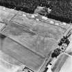
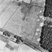
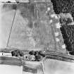
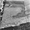
NX15NW 105 148 570.
Field boundaries extending over for 170m to the E of Woodend have been recorded as cropmarks on oblique aerial photographs (RCAHMSAP 1995). In one sector two ditches, placed about 2.5m apart, run parallel, defining what may have been a trackway. The 1st edition of the OS 6-inch map (Wigtownshire 1850, sheet xvii) deos not depict any features in this area.
Information from RCAHMS (KB) 30 June 1999
Aerial Photographic Transcription (19 July 2010 - 20 July 2010)
Note (7 March 2022)
The location, classification and period of this site have been reviewed and changed from FIELD BOUNDARY(S) (PERIOD UNASSIGNED), TRACK (PERIOD UNASSIGNED)(POSSIBLE).

