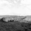
|
Photographs and Off-line Digital Images |
RC 5165 PO |
Papers of Professor John R Hume, economic and industrial historian, Glasgow, Scotland |
View looking East |
1974 |
Item Level |
|
|
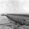
Photographs and Off-line Digital Images |
RC 5166 PO |
Papers of Professor John R Hume, economic and industrial historian, Glasgow, Scotland |
View looking South East |
1974 |
Item Level |
|
|
Prints and Drawings |
RCD 31/1 |
|
Mechanical copy of drawing showing plans and dimensions of Harbours, Wharfs and Ferry-Piers.
Kirkwall Harbour, Fortrose Harbour, Cullen Harbour, Avoch Harbour, Peterhead Harbour, Portmaholmach Harbour, Channery Point-Ferry Pier, Ballintraed Harbour, Nairn Harbour, Gordoun Harbour, Burgh-head Harbour, Fraserburgh Harbour, Invergordon Ferry Piers, Dingwall Canal, Bamff Harbour, Inverfarigaig Landing-pier, St. Catherines Ferry Pier, Portree Harbour, Corran of Ardgower Pier(West side), East Tarbert Harbour, Kyle Haken S.W. Ferry Pier, Corran of Ardgower Ferry Pier (East side), Feoline Harbour, Kyle Haken N.E. Ferry Pier, Tobermory Harbour, Kyle Rhea Ferry Pier (North side), Small Isles Harbour, Kyle Rhea Fery Pier (South side), Pier for Dornie Ferry.
Titled: 'Plans And Dimensions Of Harbours, Wharfs And Ferry-Piers, Made Or Improved Under
The Direction Of The Commissioners For Highland Roads And Bridges, 1806-1821. Thos. Telford,
Engineer.' |
1806 |
Item Level |
|
 |
On-line Digital Images |
SC 435179 |
Papers of Professor John R Hume, economic and industrial historian, Glasgow, Scotland |
Balintraid, Pier
View looking E showing S face of pier |
1974 |
Item Level |
|
 |
On-line Digital Images |
SC 435180 |
Papers of Professor John R Hume, economic and industrial historian, Glasgow, Scotland |
Balintraid, Pier
View looing S showing W side of pier and curved end |
1974 |
Item Level |
|
|
Manuscripts |
MS 726/167 |
Records of CFA Archaeology Ltd, archaeologists, Musselburgh, East Lothian, Scotland |
Coastal Assessment Survey: Inner Moray Firth, Volumes 1 and 2. |
14/12/1998 |
Item Level |
|
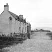 |
On-line Digital Images |
SC 498680 |
Papers of Professor John R Hume, economic and industrial historian, Glasgow, Scotland |
Balintraid Pier, House
View looking ESE showing WNW and SSW fronts of house with pier in background |
30/5/1976 |
Item Level |
|
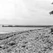 |
On-line Digital Images |
SC 498681 |
Papers of Professor John R Hume, economic and industrial historian, Glasgow, Scotland |
Balintraid Pier
View from N showing NNE front |
30/5/1976 |
Item Level |
|
|
Manuscripts |
MS 749/2840 |
Papers of Professor John R Hume, economic and industrial historian, Glasgow, Scotland |
John R Hume Industrial/CBA cards
Filed under Ross and Cromarty, Kilmuir Easter parish. Contact prints attached (Hume photo index number H76/154/4, 5). (see NMRS MS/749 entry for Collection description) |
30/5/1976 |
Item Level |
|
 |
On-line Digital Images |
SC 796236 |
Papers of Professor John R Hume, economic and industrial historian, Glasgow, Scotland |
View from W showing SSW front |
13/5/1974 |
Item Level |
|
|
Manuscripts |
MS 2776/1/12 |
Historic Scotland Archive Project |
Survey archive: Site record sheets, site record sheets with field notes and monument forms from Moray, Beauly and Cromarty Firth Coastal Assessment Survey. Sheet 12. |
9/1998 |
Item Level |
|
|
Prints and Drawings |
BD 104/1/12 |
Historic Scotland Archive Project |
Survey archive: 1:25,000 OS Pathfinder map depicting site locations from the Moray, Beauly and Cromarty Firth Coastal Assessment Survey. Sheet 12. |
9/1998 |
Item Level |
|
|
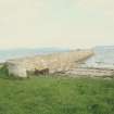
Photographs and Off-line Digital Images |
DP 125797 |
Buildings at Risk Register |
Balintraid Pier Approach from south west |
19/4/2010 |
Item Level |
|
|
Photographs and Off-line Digital Images |
DP 125798 |
Buildings at Risk Register |
Balintraid Pier Collapsed sections |
19/4/2010 |
Item Level |
|
|
Photographs and Off-line Digital Images |
DP 125799 |
Buildings at Risk Register |
Balintraid Pier Decaying masonry |
19/4/2010 |
Item Level |
|
|
Photographs and Off-line Digital Images |
DP 125800 |
Buildings at Risk Register |
Balintraid Pier Collapsed section |
19/4/2010 |
Item Level |
|
|
Photographs and Off-line Digital Images |
DP 139513 |
Buildings at Risk Register |
Balintraid Pier - Approach |
19/6/2012 |
Item Level |
|
|
Photographs and Off-line Digital Images |
DP 139514 |
Buildings at Risk Register |
Balintraid Pier - Collapsed section |
19/6/2012 |
Item Level |
|
|
Photographs and Off-line Digital Images |
DP 139515 |
Buildings at Risk Register |
Balintraid Pier - Collapsing section |
19/6/2012 |
Item Level |
|
|
Photographs and Off-line Digital Images |
DP 139516 |
Buildings at Risk Register |
Balintraid Pier - Missing masonry |
19/6/2012 |
Item Level |
|
|
Photographs and Off-line Digital Images |
DP 139517 |
Buildings at Risk Register |
Balintraid Pier- From North |
19/6/2012 |
Item Level |
|
|
Photographs and Off-line Digital Images |
DP 139518 |
Buildings at Risk Register |
Balintraid Pier -From West |
19/6/2012 |
Item Level |
|
|
Photographs and Off-line Digital Images |
DP 192324 |
Buildings at Risk Register |
Approach |
4/10/2013 |
Item Level |
|
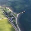 |
On-line Digital Images |
DP 238533 |
Historic Environment Scotland |
Oblique aerial view. |
19/7/2016 |
Item Level |
|


