
Scheduled Maintenance
Please be advised that this website will undergo scheduled maintenance on the following dates: •
Tuesday 3rd December 11:00-15:00
During these times, some services may be temporarily unavailable. We apologise for any inconvenience this may cause.
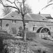
Blyth Bridge, Blyth Mill


Grain Mill (19th Century), Water Wheel (19th Century)
Site Name Blyth Bridge, Blyth Mill
Classification Grain Mill (19th Century), Water Wheel (19th Century)
Alternative Name(s) The Old Mill Inn; Restaurant
Canmore ID 145526
Site Number NT14NW 52
NGR NT 13200 45255
Datum OSGB36 - NGR
Permalink http://canmore.org.uk/site/145526


- Council Scottish Borders, The
- Parish Newlands
- Former Region Borders
- Former District Tweeddale
- Former County Peebles-shire
NT14NW 52 13200 45255.
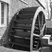
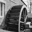
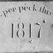
(Location cited as NT 132 453). Blyth Mill, built 1817. 2-storey L plan building with an 8-spoke, low-breast shrouded paddle-wheel with wooden spokes and paddles and iron axle and rings, 4ft wide by 15ft 6in dameter (1.22 by 4.72m).
J R Hume 1976.
NT14NW 52 13200 45255
Blyth Bridge, Old Mill now operates as a restaurant. Information from RCAHMS (LKFJ), June 2002.
Sbc Note
Visibility: This is an upstanding building.
Information from Scottish Borders Council.

